|
LRO Narrow Angle Camera Views of the
Apollo Landing Sites
Including the
fourth LROC PDS Dataset
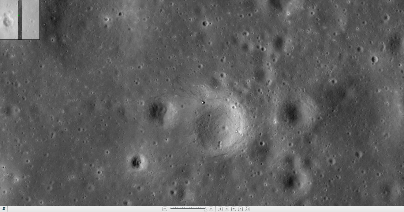
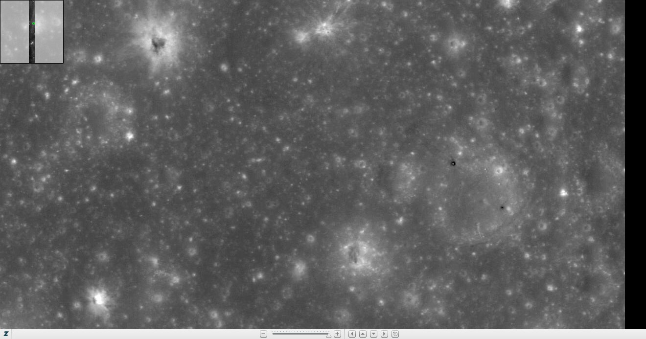
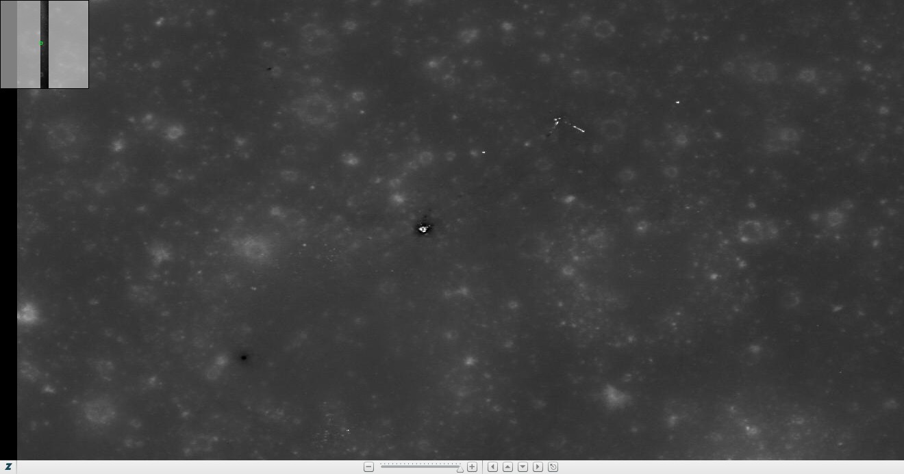
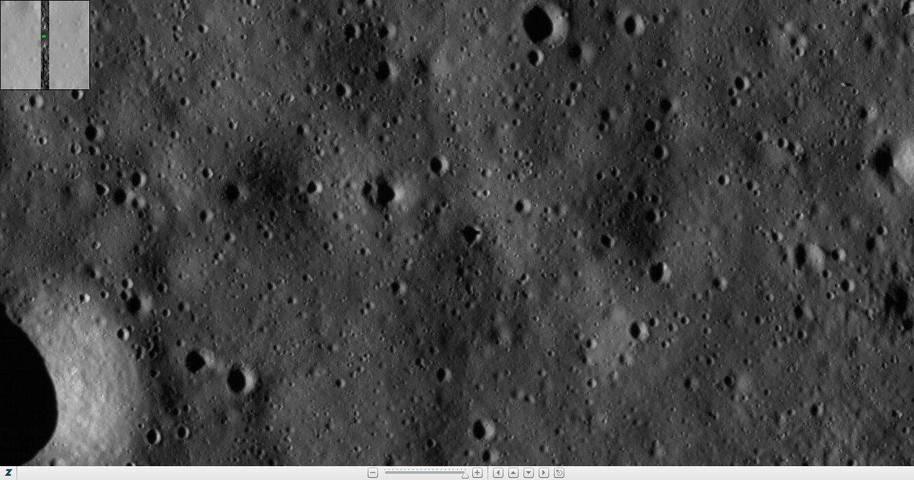
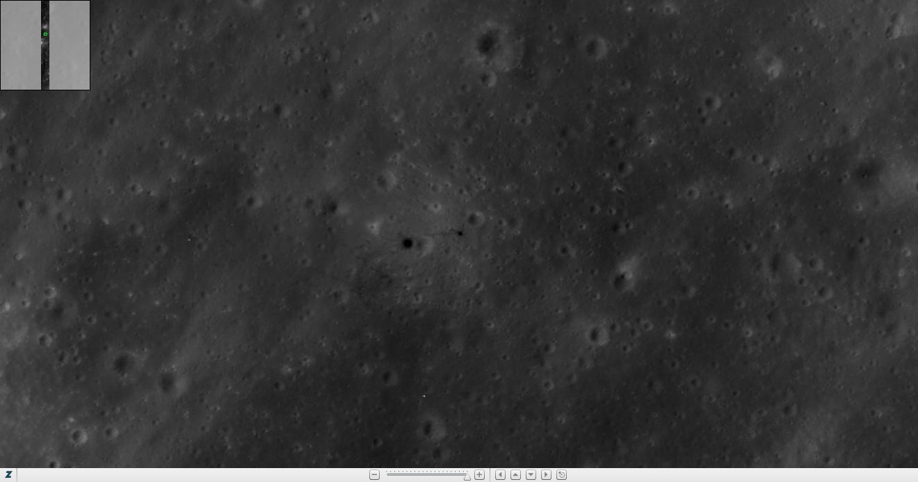
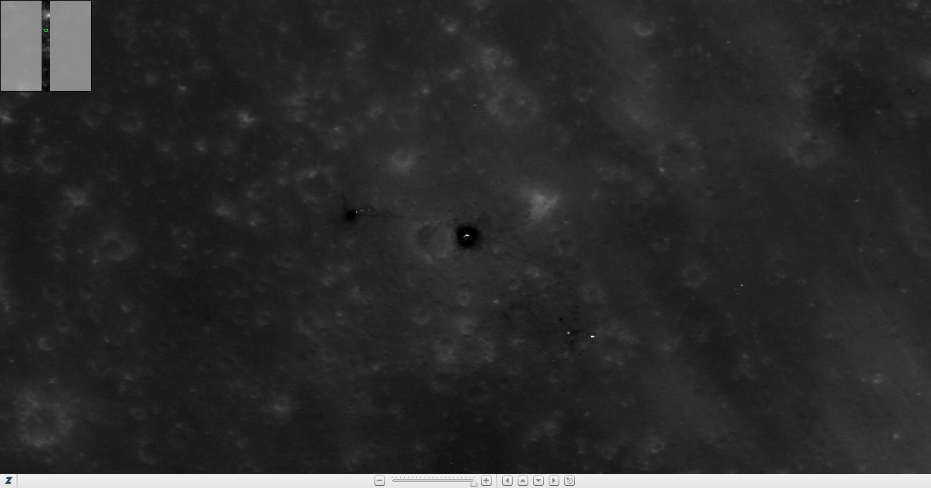
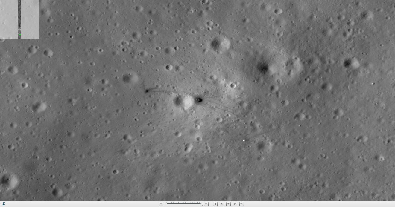
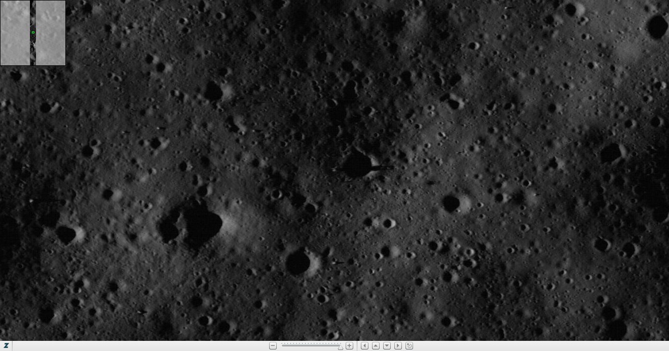
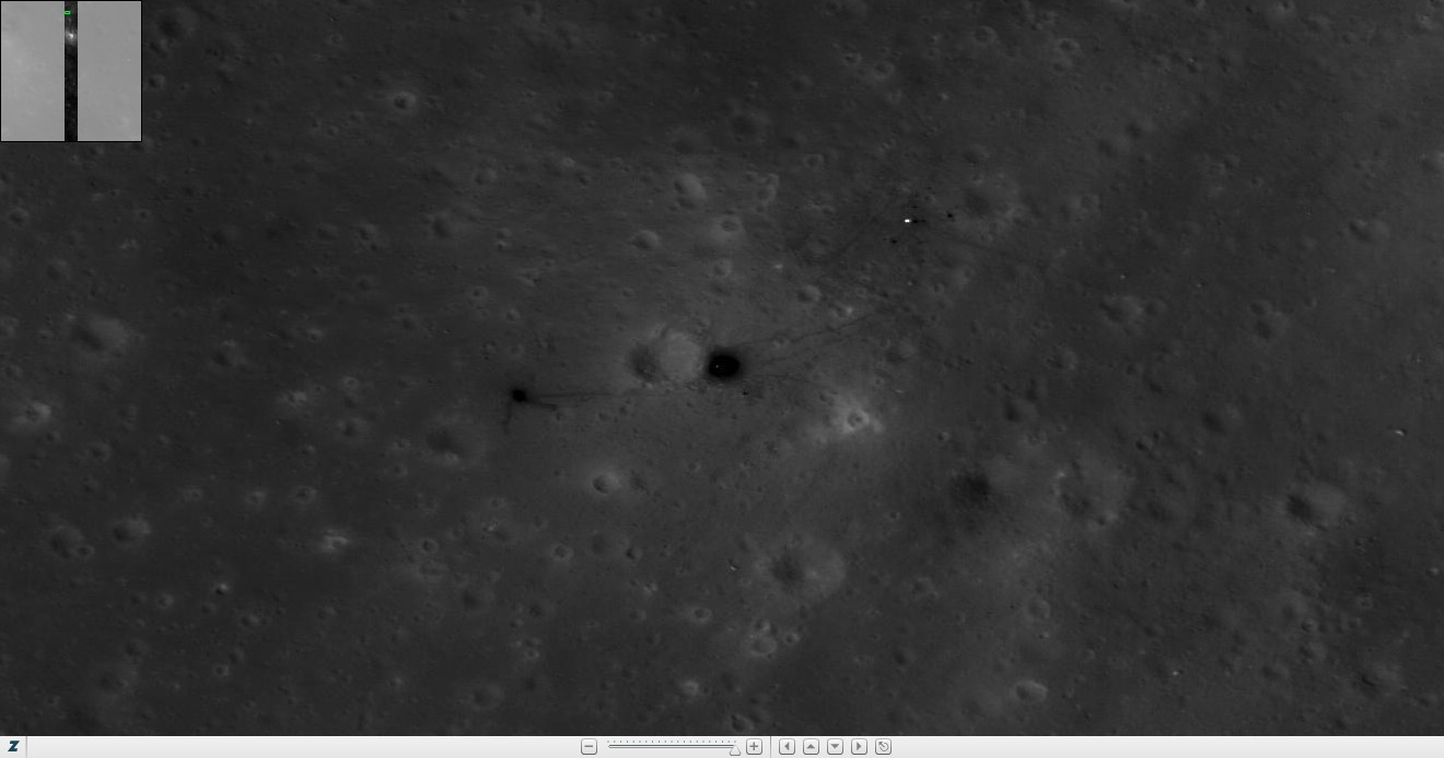
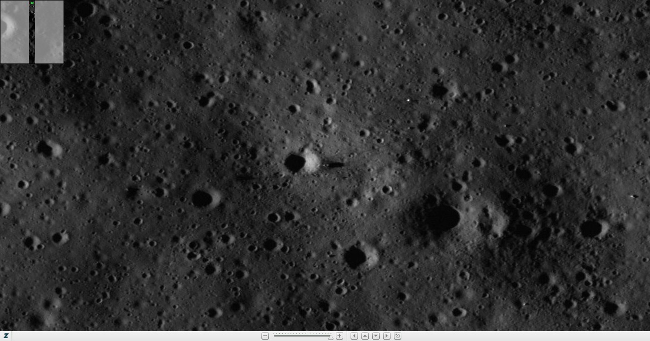
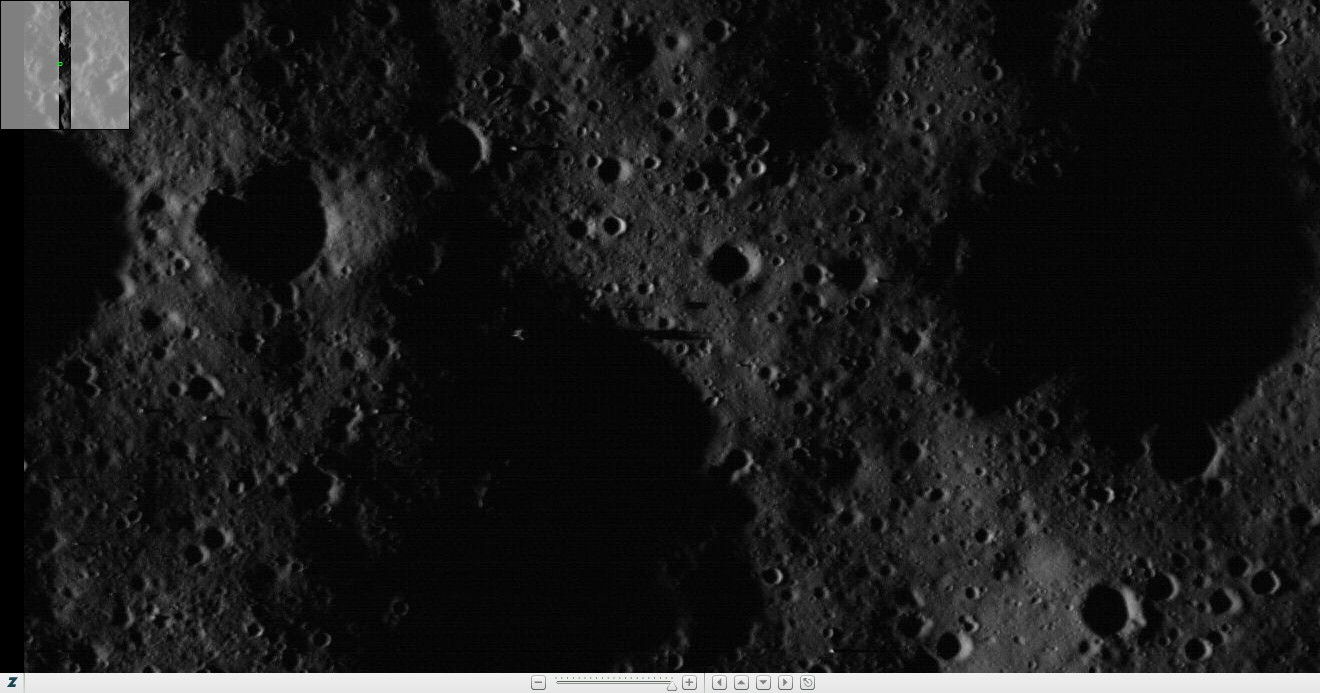
Shown below are all of the currently available
LRO Narrow Angle Camera (NAC) images of the Apollo landing sites which have
been taken by the Lunar Reconnaissance Orbiter. Each Apollo landing site can be
found in one of the two image pairs and occasionally in both image pairs in
cases where the landing site is at the extreme left or right edges of the
images. Image names with a yellow L or R show LM descent
stages. Image names with an orange L or R show other Apollo
hardware.
Please see
Additional information about the
LRO images if you would like more information about the LRO Narrow Angle
Camera images in general, and if you would like information about free Windows
software which is available for viewing the LRO images or converting the images
to other image formats.
Simply click on any image in order to view
Arizona State University's version of the raw high resolution LRO NAC image and
the associated image data. Click on the thumbnail beneath an image pair to view
a close-up of the landing site and to see where the landing site is located
within the full NAC image. All thumbnails, when clicked on, should
automatically open the full image in a new browser tab or browser window.
Occasionally, while initially loading this
page, not every image thumbnail gets loaded from ASU's web server. Simply click
on one of the "Reload This Web Page" buttons located at the top of each table
of image thumbnails. Reloading the page just once usually retrieves all of the
images which initially were not retrieved from ASU's web server.
Credit
Information: All LRO NAC photos are credit NASA/GSFC/Arizona State
University.
Apollo
11 LROC NAC Image Information
Revision
Level: PDS Releases 1 through 6 |
| NAC Image Name |
Date |
Time |
LM |
LM |
Mission |
Slew |
X Scale |
Y Scale |
Incidence |
Solar |
Incidence |
Comments |
| |
|
|
Location |
Location |
Phase |
Angle |
(m/pixel) |
(m/pixel) |
Angle |
Altitude |
Direction |
|
| |
|
|
(Column) |
(Row) |
Name |
(degrees) |
|
|
(degrees) |
(degrees) |
|
|
| M102000149RE |
07/12/2009 |
01:08:02 |
2469 |
20897 |
COMMISSIONING |
-12.14 |
1.18 |
1.18 |
79.75 |
10.25 |
west |
True first look, Stereo Pair #1 |
| M102014464RE |
07/12/2009 |
05:06:37 |
3205 |
21815 |
COMMISSIONING |
20.00 |
1.29 |
1.17 |
81.76 |
8.24 |
west |
Published first look, Stereo Pair #1 |
| M104362199RE |
08/08/2009 |
09:15:32 |
3991 |
30151 |
COMMISSIONING |
-6.98 |
1.17 |
1.19 |
53.97 |
36.03 |
west |
|
| M106719774LE |
09/04/2009 |
16:18:27 |
4086 |
32784 |
COMMISSIONING |
-10.95 |
1.28 |
1.26 |
27.23 |
62.77 |
west |
|
| M109080308RE |
10/01/2009 |
23:50:40 |
3153 |
22906 |
NOMINAL |
-13.99 |
0.53 |
0.54 |
2.19 |
87.81 |
west |
|
| M111443315RE |
10/29/2009 |
08:14:07 |
4233 |
24283 |
NOMINAL |
2.00 |
0.49 |
0.54 |
26.24 |
63.76 |
east |
|
| M113799518RE |
11/25/2009 |
14:44:11 |
3014 |
48275 |
NOMINAL |
-15.72 |
0.51 |
0.54 |
54.21 |
35.79 |
east |
Oblique Stereo Pair #1 |
| M116161085RE |
12/22/2009 |
22:43:38 |
3110 |
13195 |
NOMINAL |
-5.07 |
0.48 |
0.55 |
81.78 |
8.22 |
east |
|
| M117338434RE |
01/05/2010 |
13:46:07 |
927 |
49376 |
NOMINAL |
-7.36 |
0.42 |
0.55 |
83.63 |
6.37 |
west |
|
| M119693197LE |
02/01/2010 |
19:52:11 |
1517 |
48159 |
NOMINAL |
18.89 |
0.46 |
0.88 |
55.08 |
34.92 |
west |
Stereo Pair #2 |
| M119699983RE |
02/01/2010 |
21:45:17 |
1452 |
47778 |
NOMINAL |
-18.46 |
0.46 |
0.90 |
55.99 |
34.01 |
west |
Stereo Pair #2 |
| M122054682RE |
03/01/2010 |
03:50:16 |
3185 |
44924 |
NOMINAL |
9.85 |
0.43 |
0.55 |
27.69 |
62.31 |
west |
|
| M129133239RE |
05/22/2010 |
02:06:13 |
2969 |
24963 |
NOMINAL |
4.37 |
0.41 |
0.55 |
53.13 |
36.87 |
east |
Oblique Stereo Pair #1 |
| M131494509LE |
06/18/2010 |
10:00:42 |
2871 |
2265 |
NOMINAL |
-5.35 |
0.40 |
0.55 |
79.22 |
10.78 |
east |
|
| M132678405RE |
07/02/2010 |
02:52:17 |
2640 |
21239 |
NOMINAL |
2.00 |
0.46 |
0.55 |
87.99 |
2.01 |
west |
|
| M135032851LE |
07/29/2010 |
08:53:03 |
3266 |
48044 |
NOMINAL |
-20.00 |
0.53 |
0.55 |
61.14 |
28.86 |
west |
Stereo Pair #3 |
| M135039651LE |
07/29/2010 |
10:46:23 |
4336 |
5001 |
NOMINAL |
15.43 |
0.49 |
0.55 |
62.02 |
27.98 |
west |
Stereo Pair #3 |
| M139755141RE |
09/22/2010 |
00:37:53 |
4084 |
2540 |
SCIENCE |
0.00 |
0.46 |
0.55 |
8.77 |
81.23 |
west |
|
| M150361817RE |
01/22/2011 |
18:55:49 |
2274 |
19619 |
SCIENCE |
10.31 |
0.40 |
0.55 |
62.61 |
27.39 |
west |
Stereo Pair #4 |
| M150368601RE |
01/22/2011 |
20:48:53 |
2096 |
21359 |
SCIENCE |
-29.97 |
0.53 |
0.55 |
63.51 |
26.49 |
west |
Stereo Pair #4 |
Apollo
11 LROC NAC Footprints at 0.67°, 23.47°
Revision Level: PDS Releases 1 through 6 |
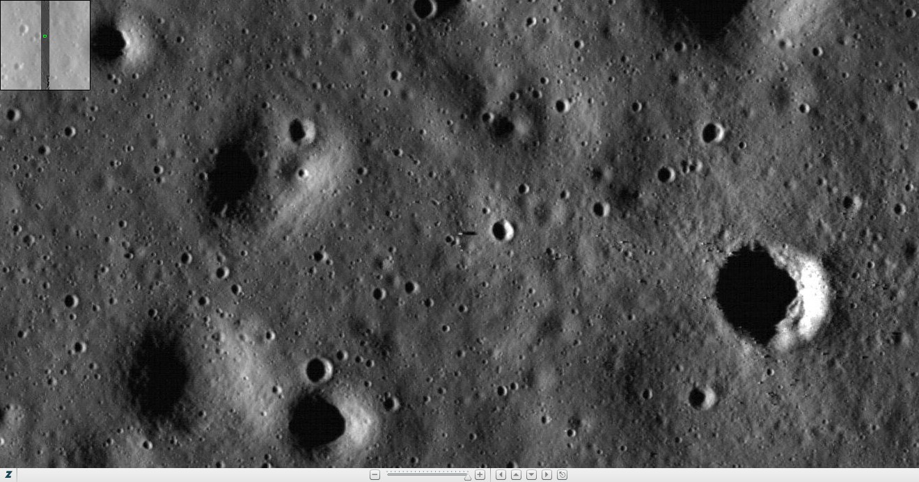
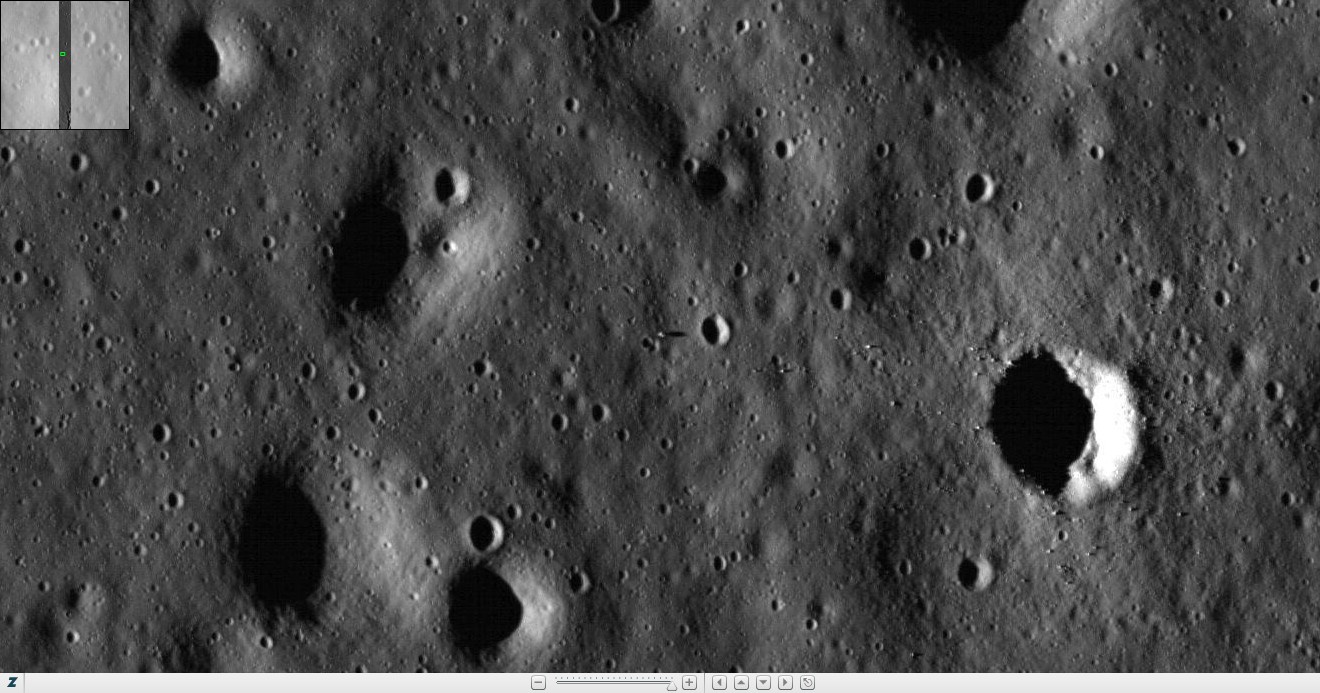
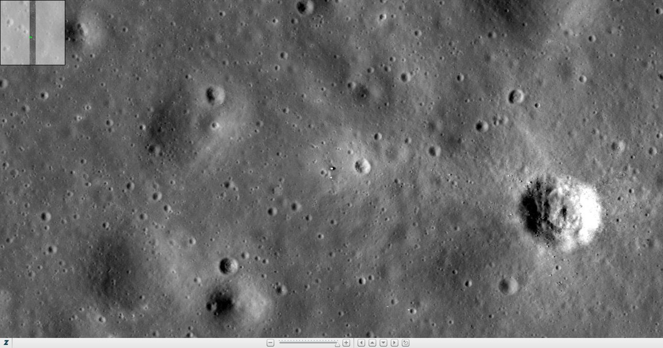
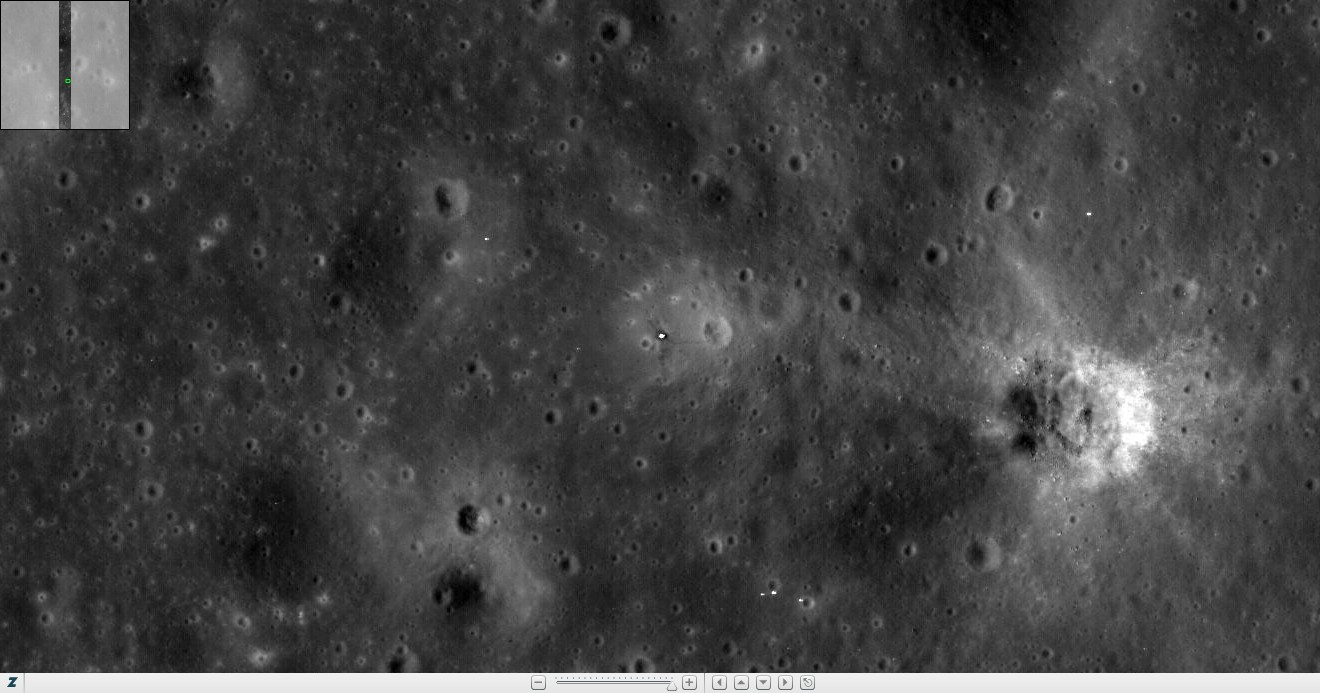
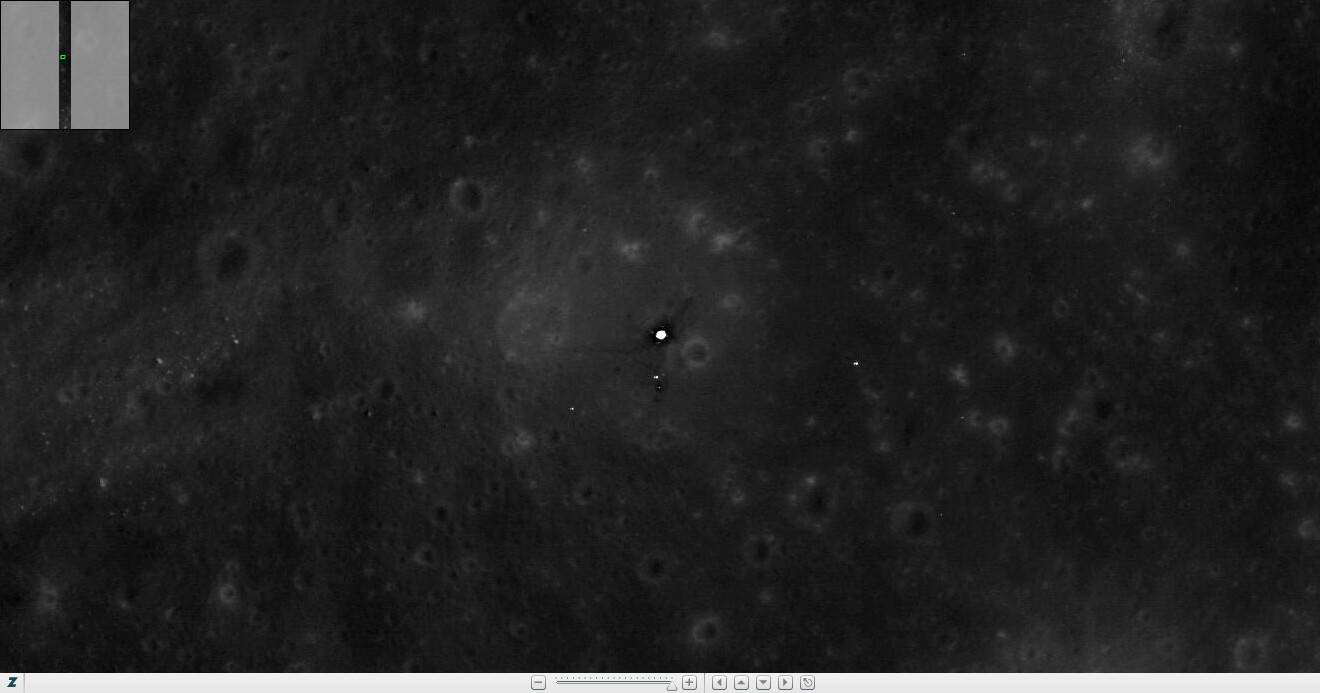
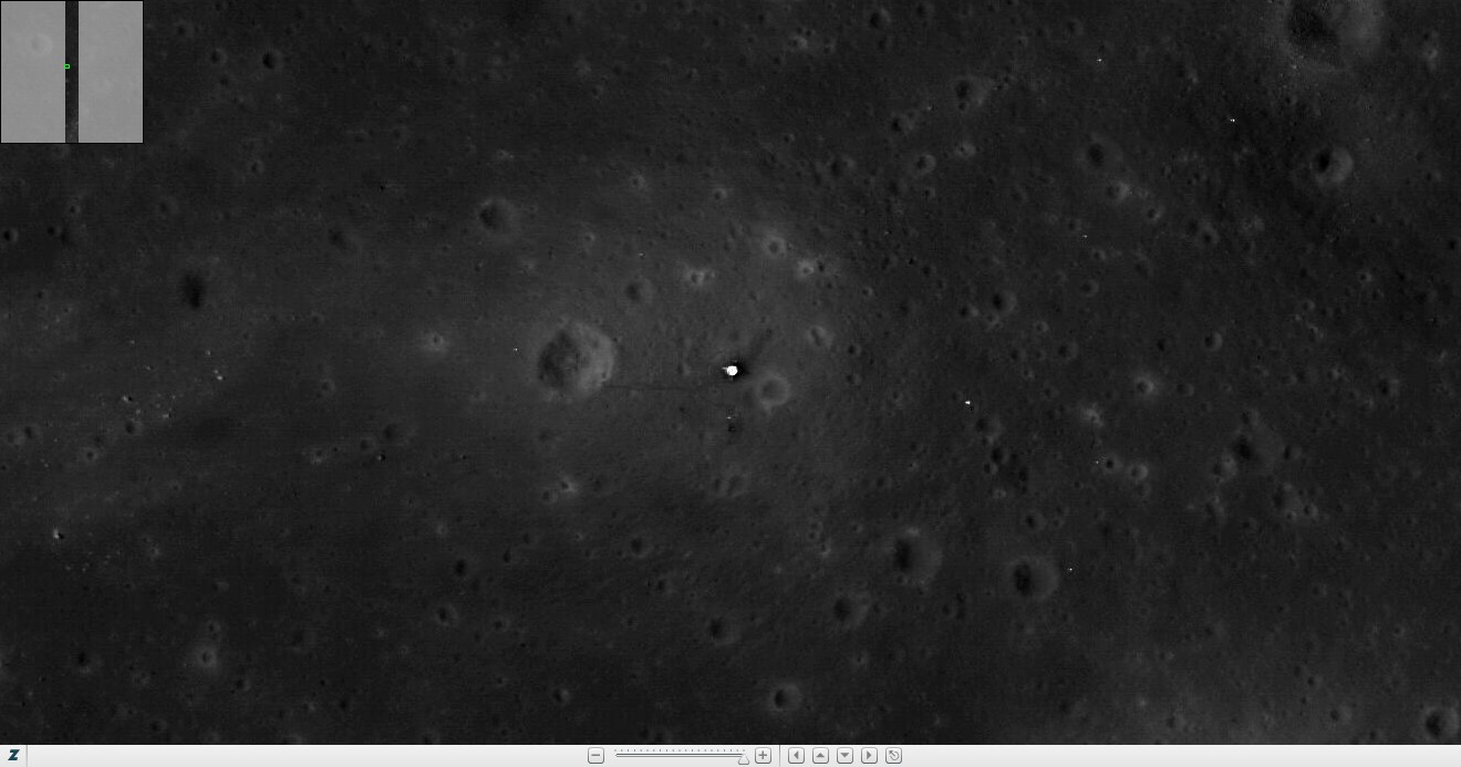
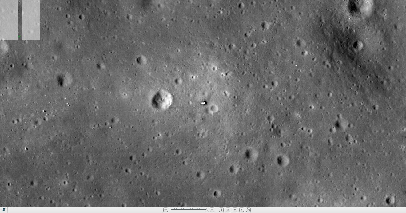
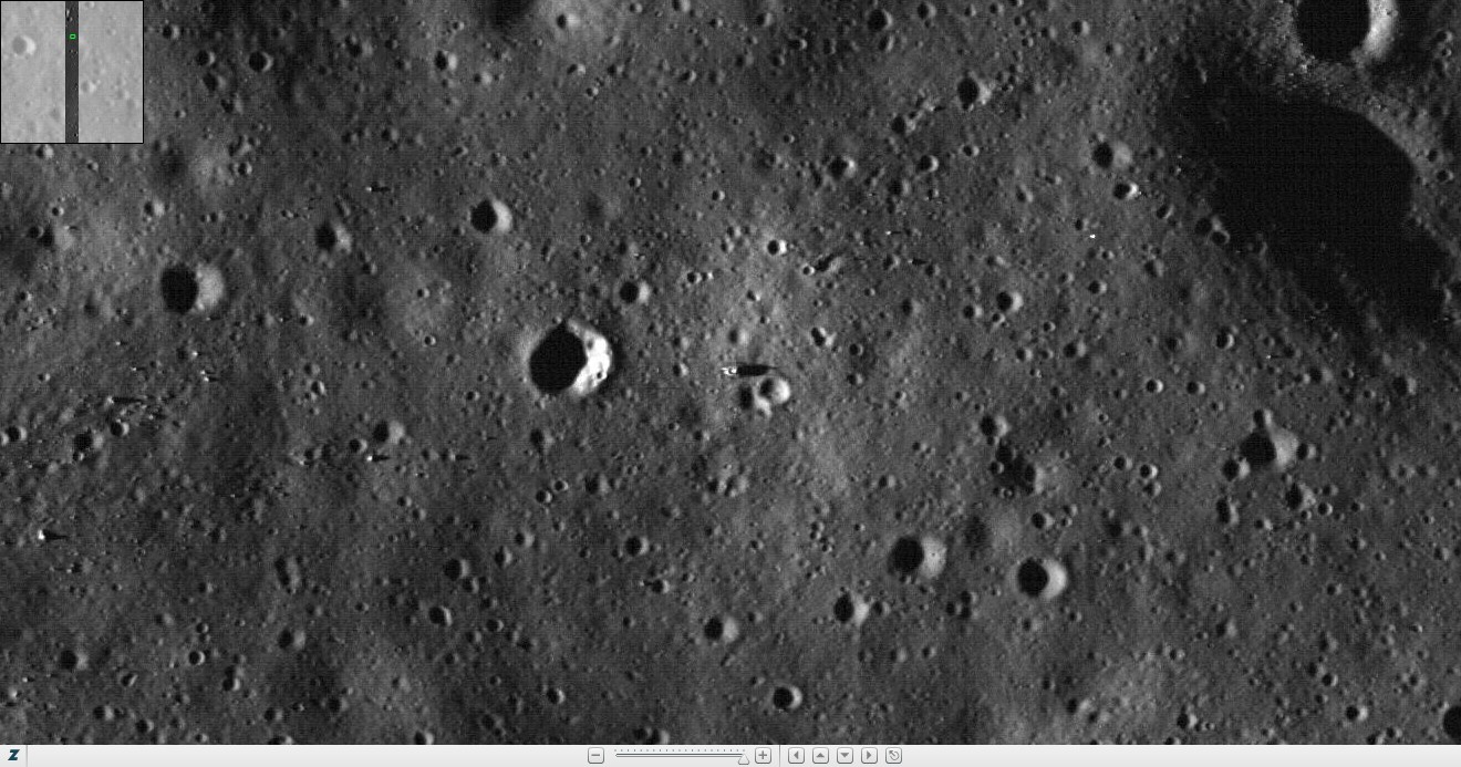
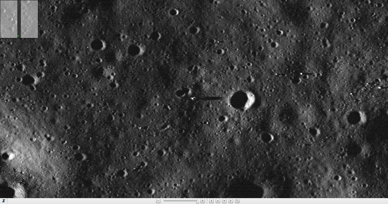
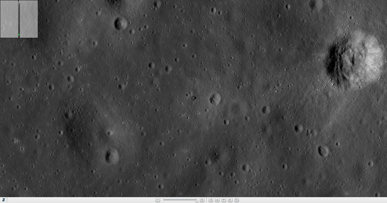
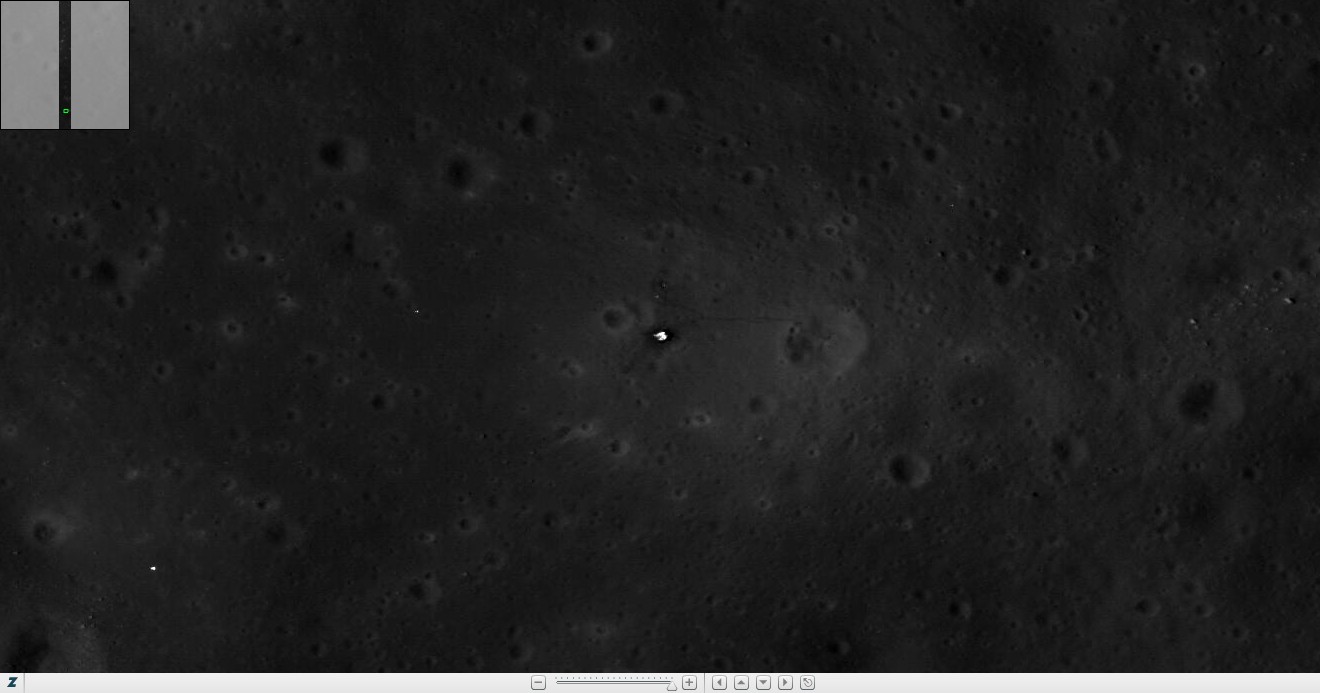
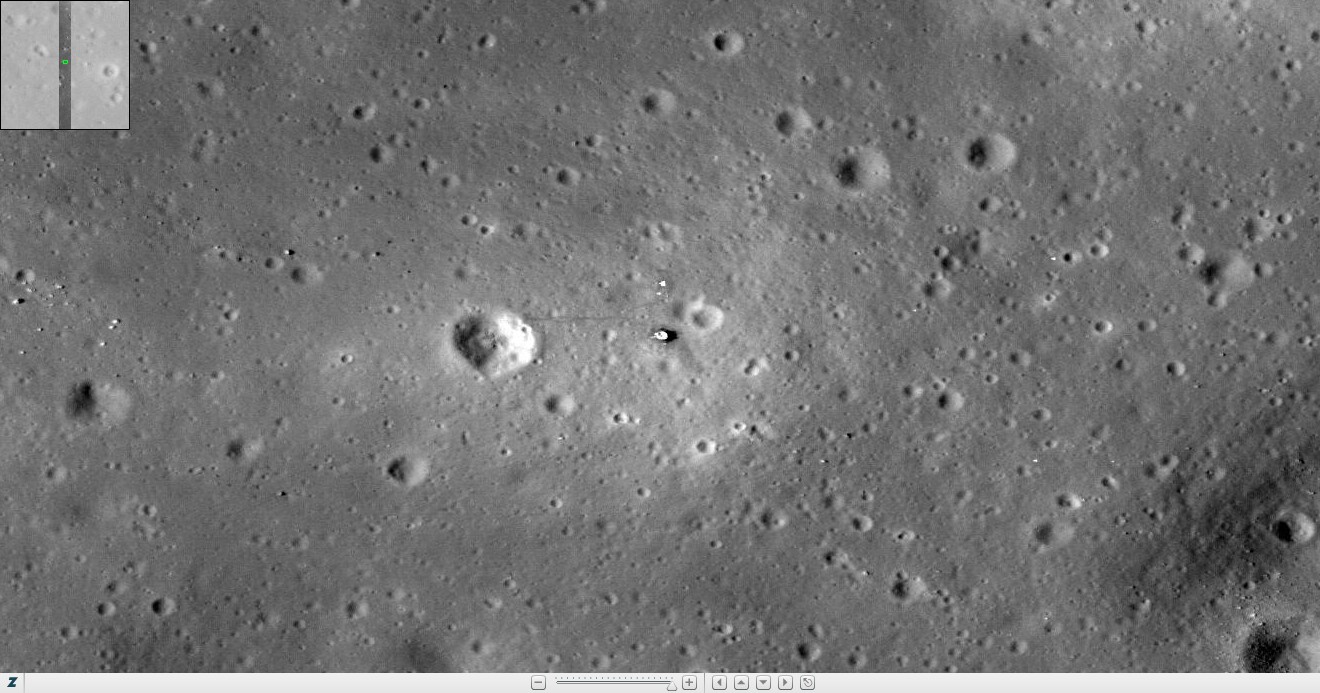
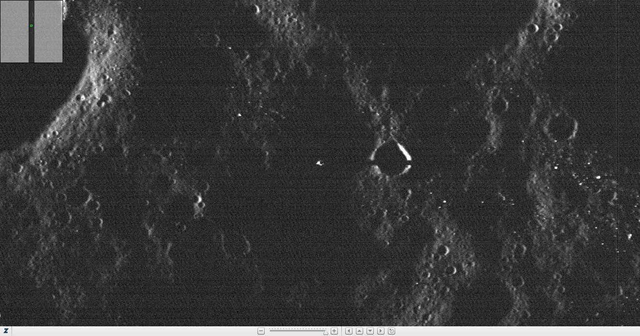
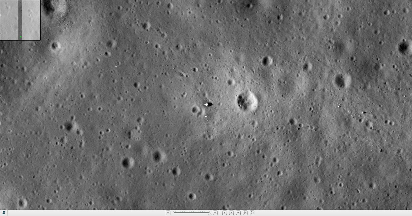
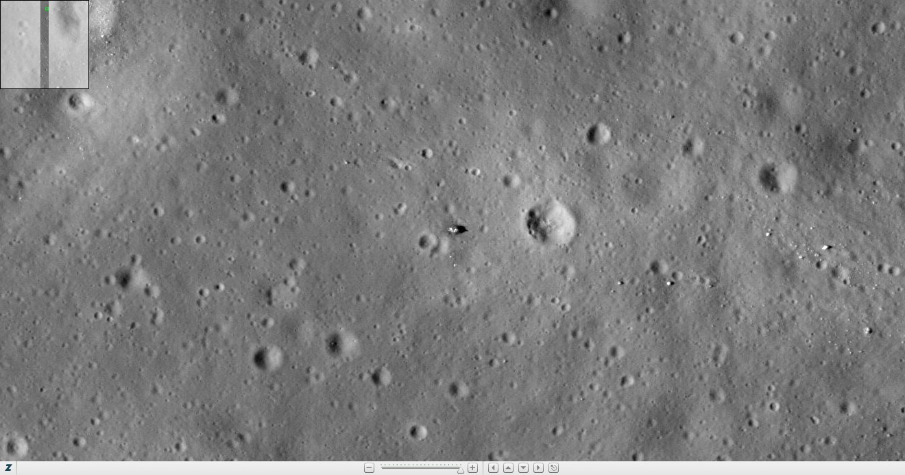
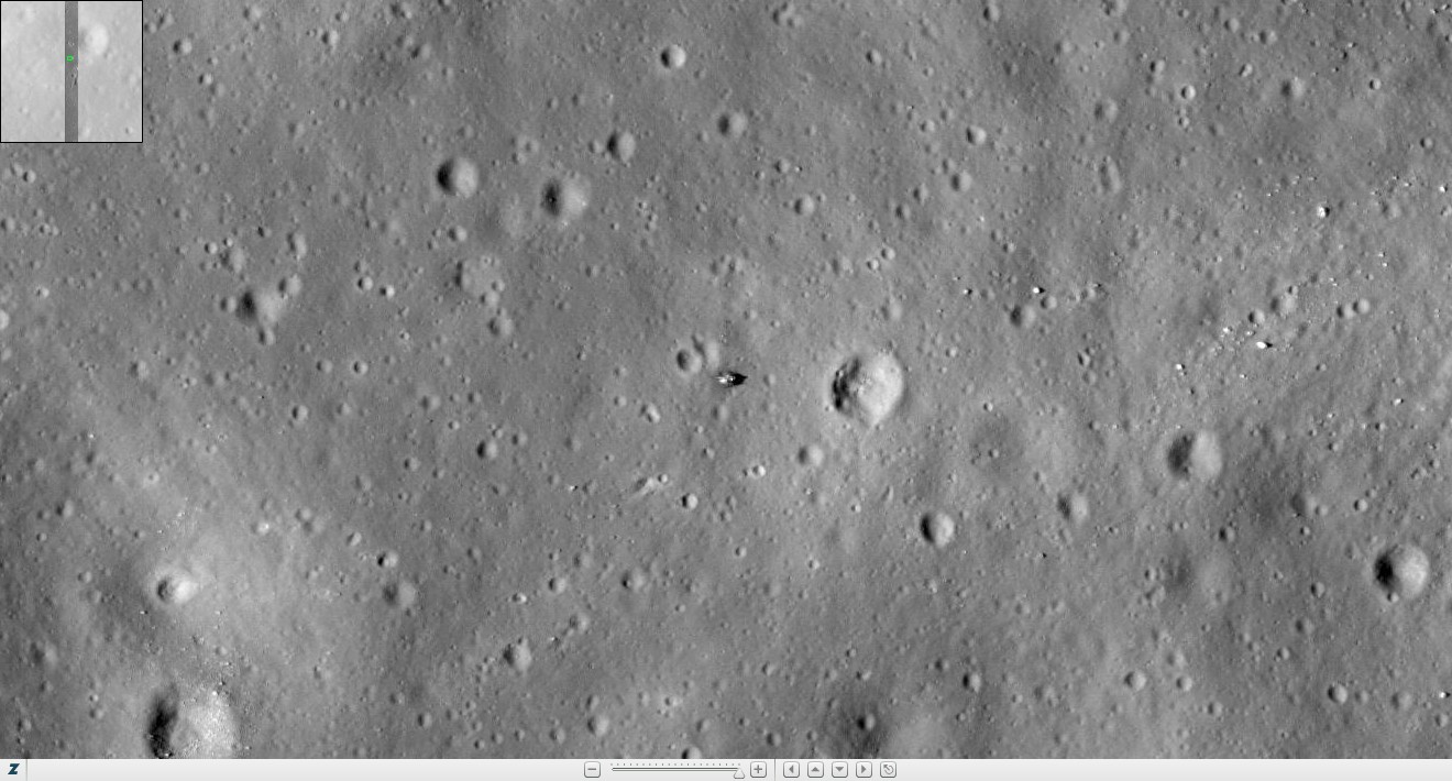
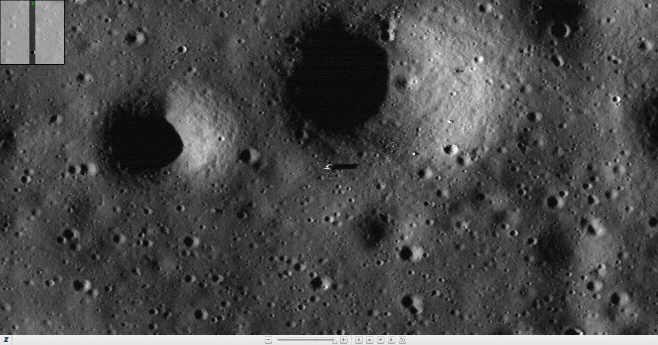
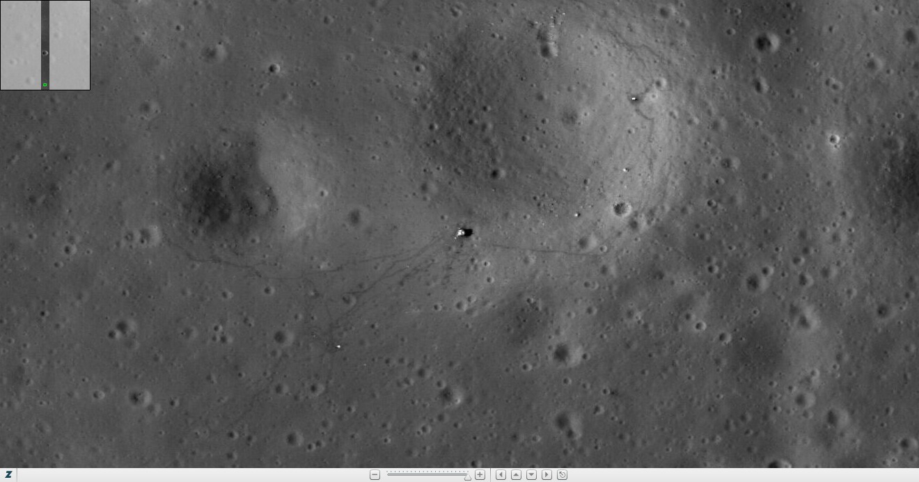
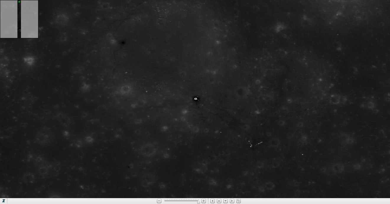
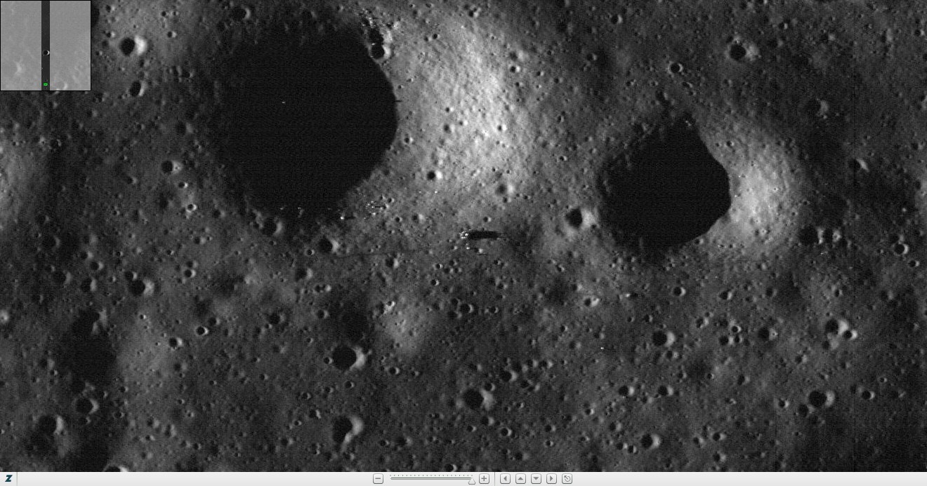
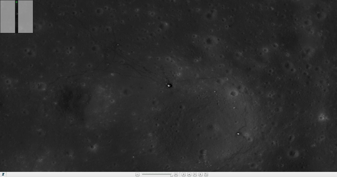
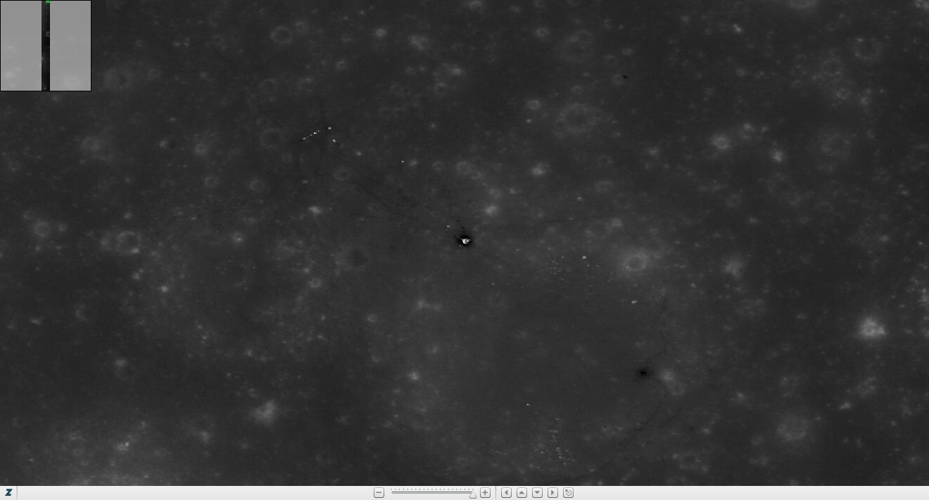
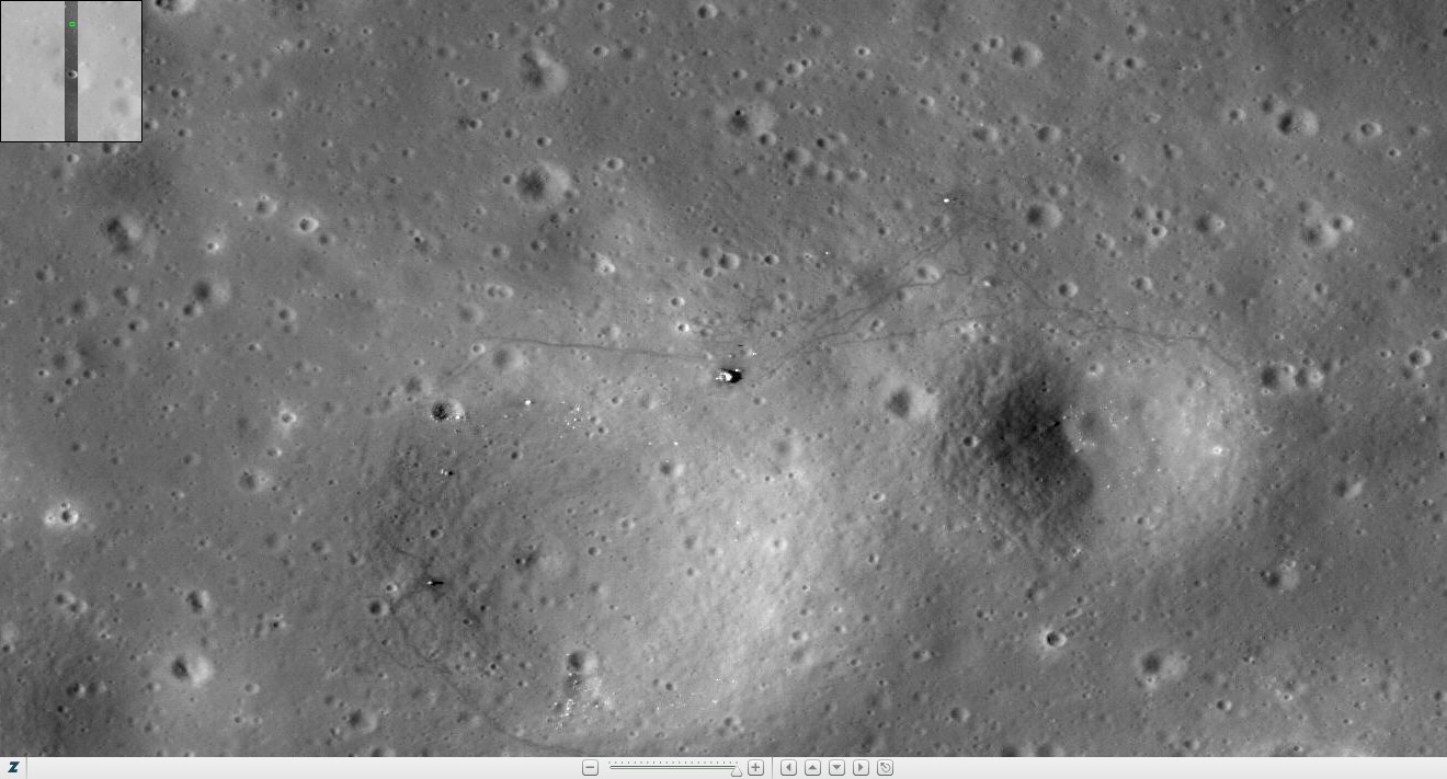
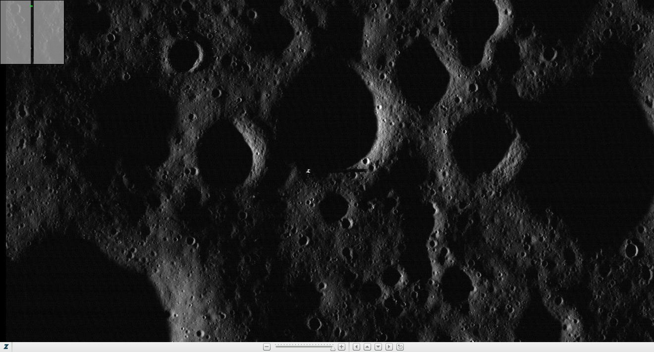
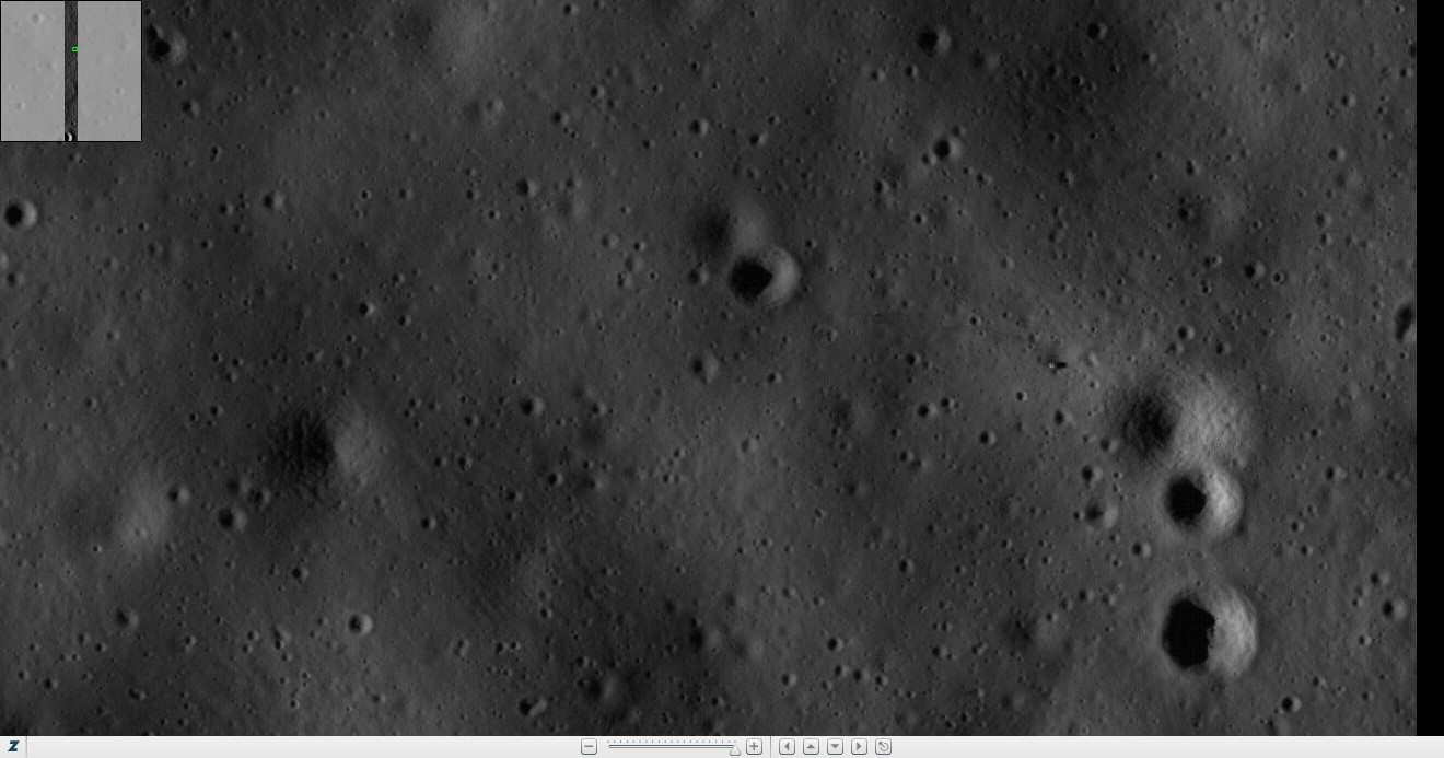
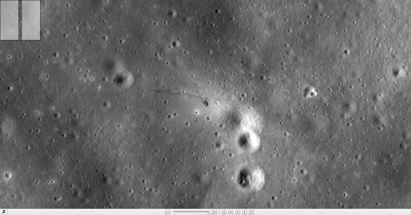
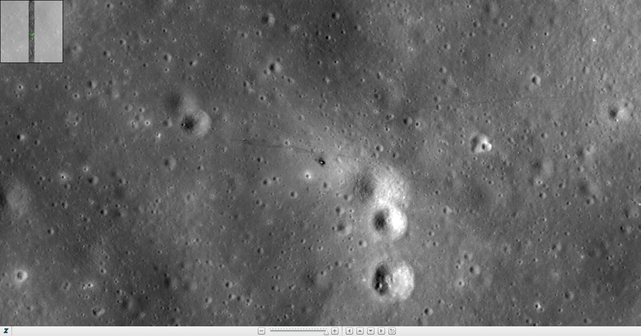
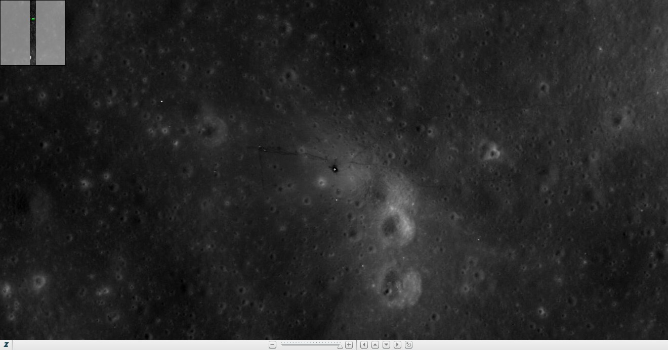
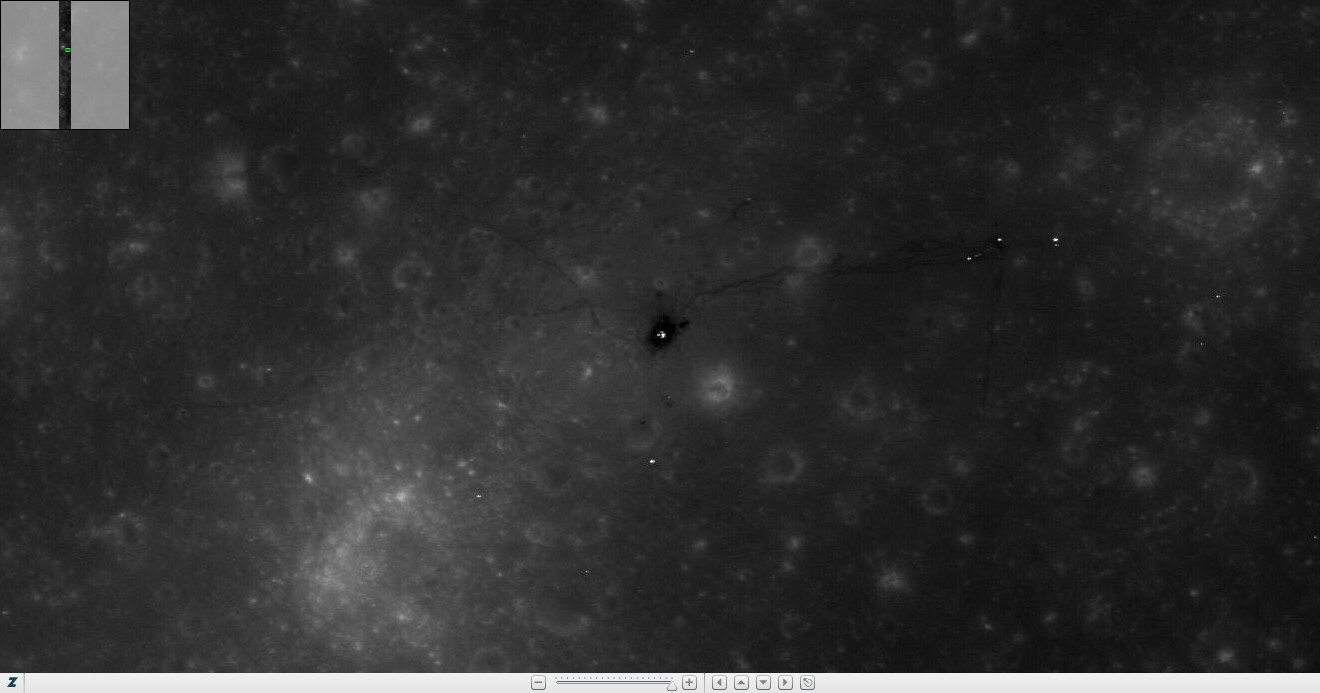
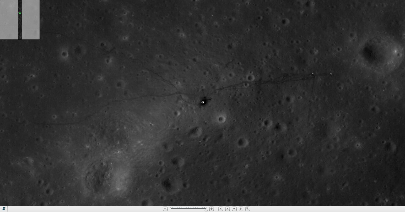
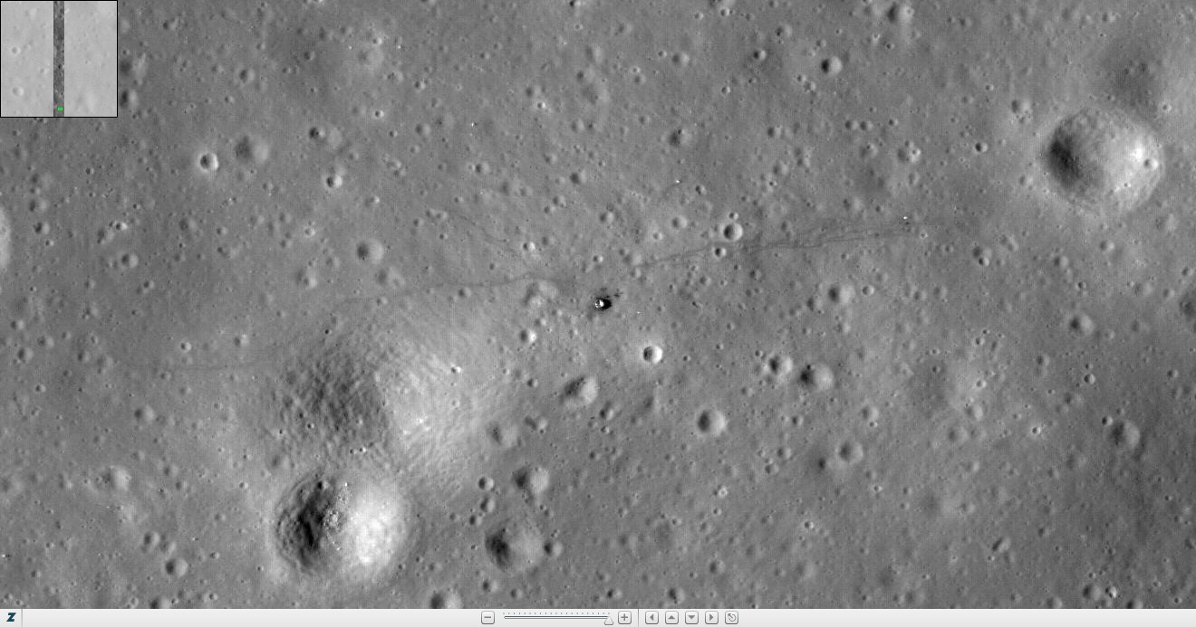
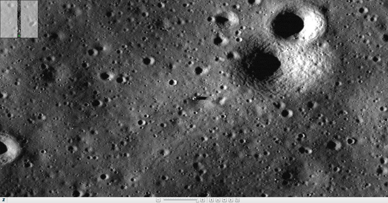
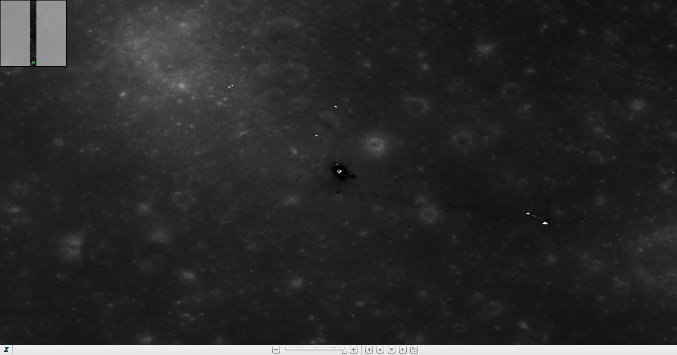
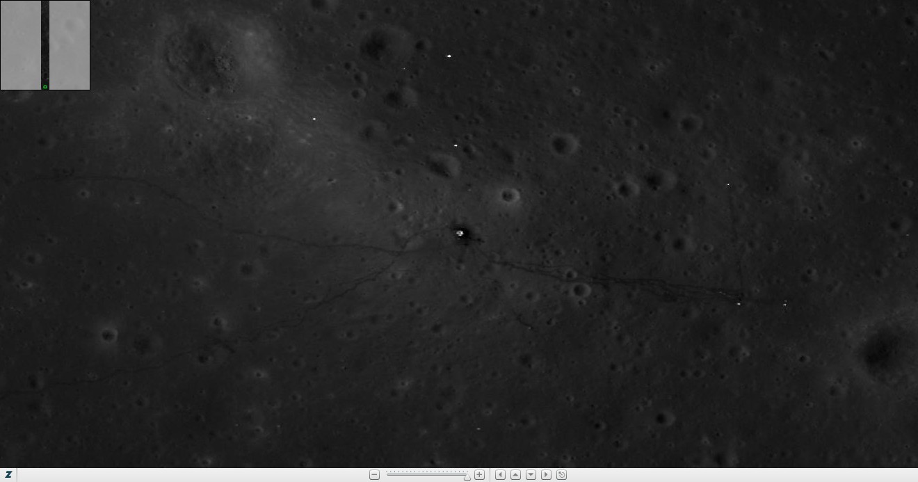
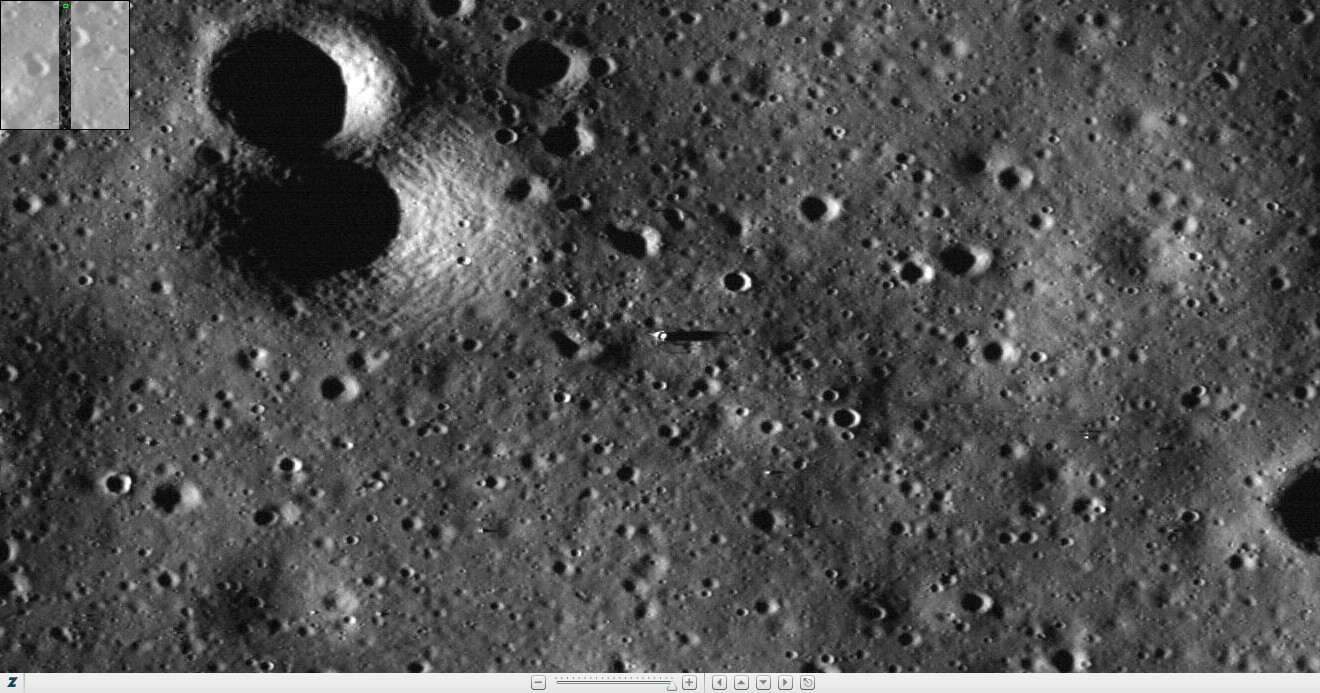
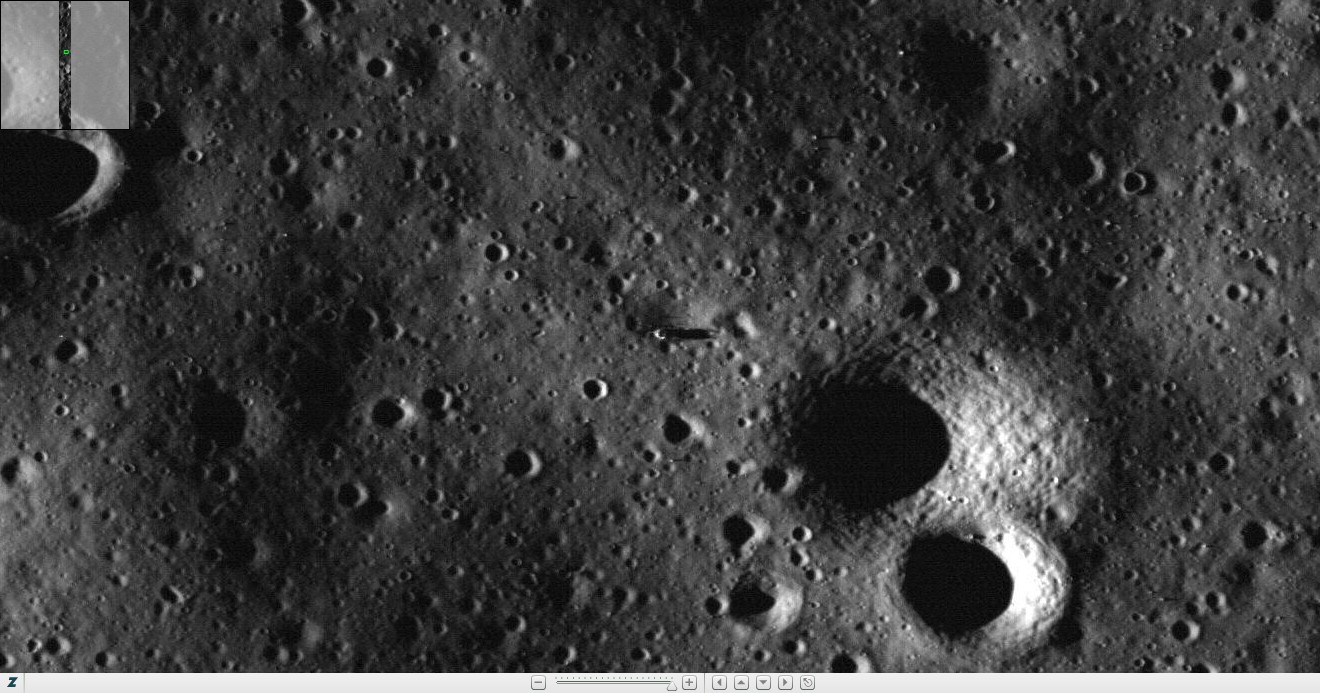
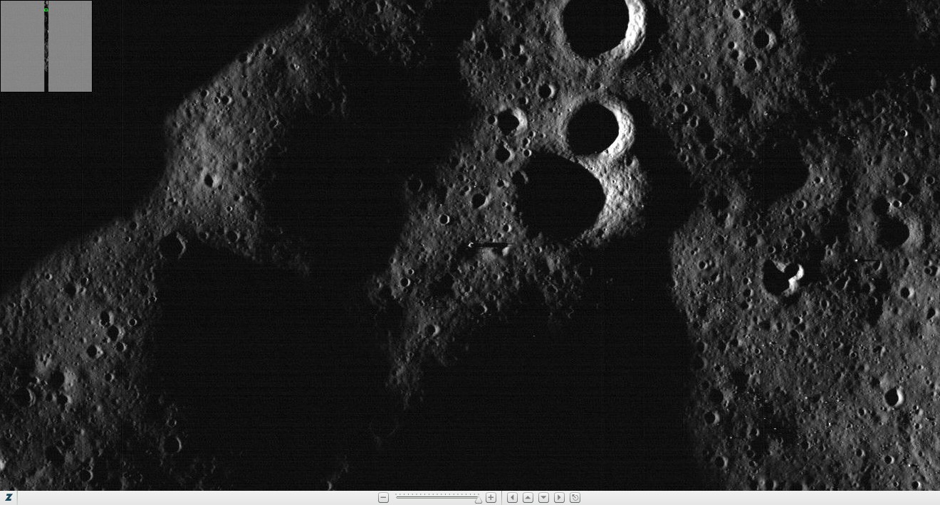
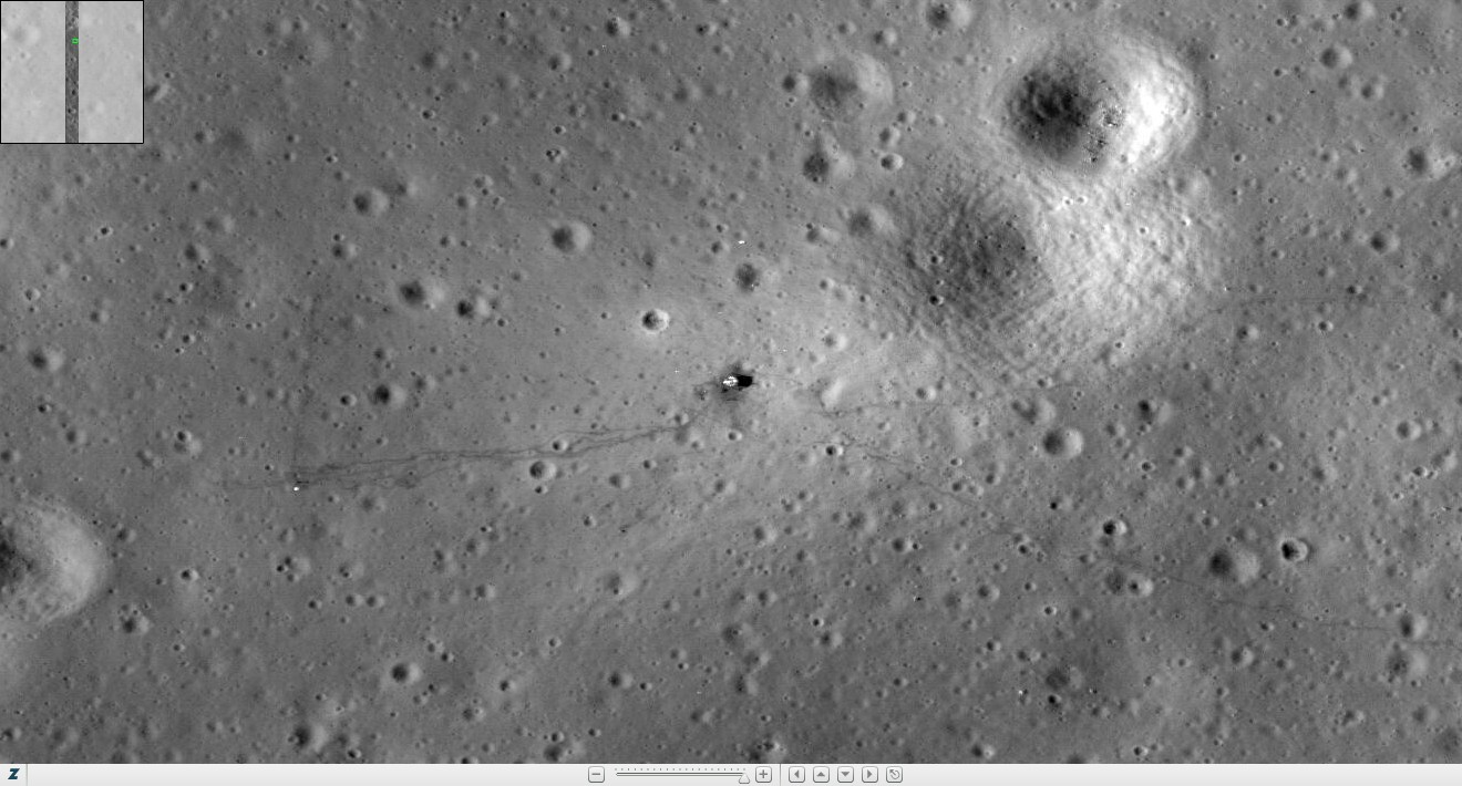
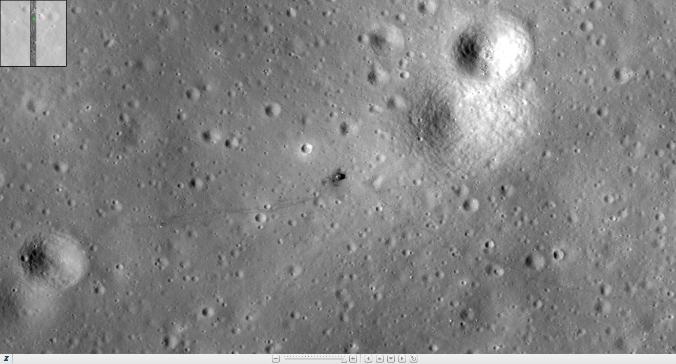
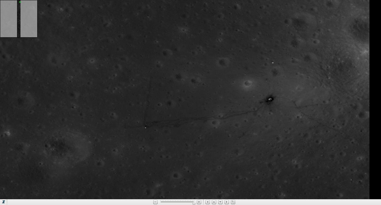
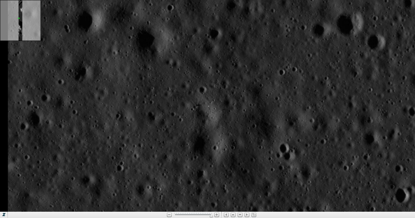
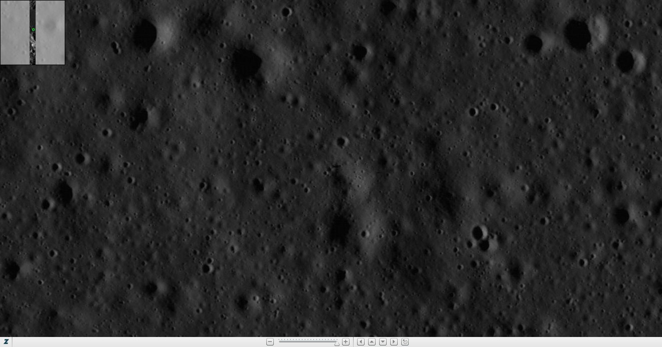
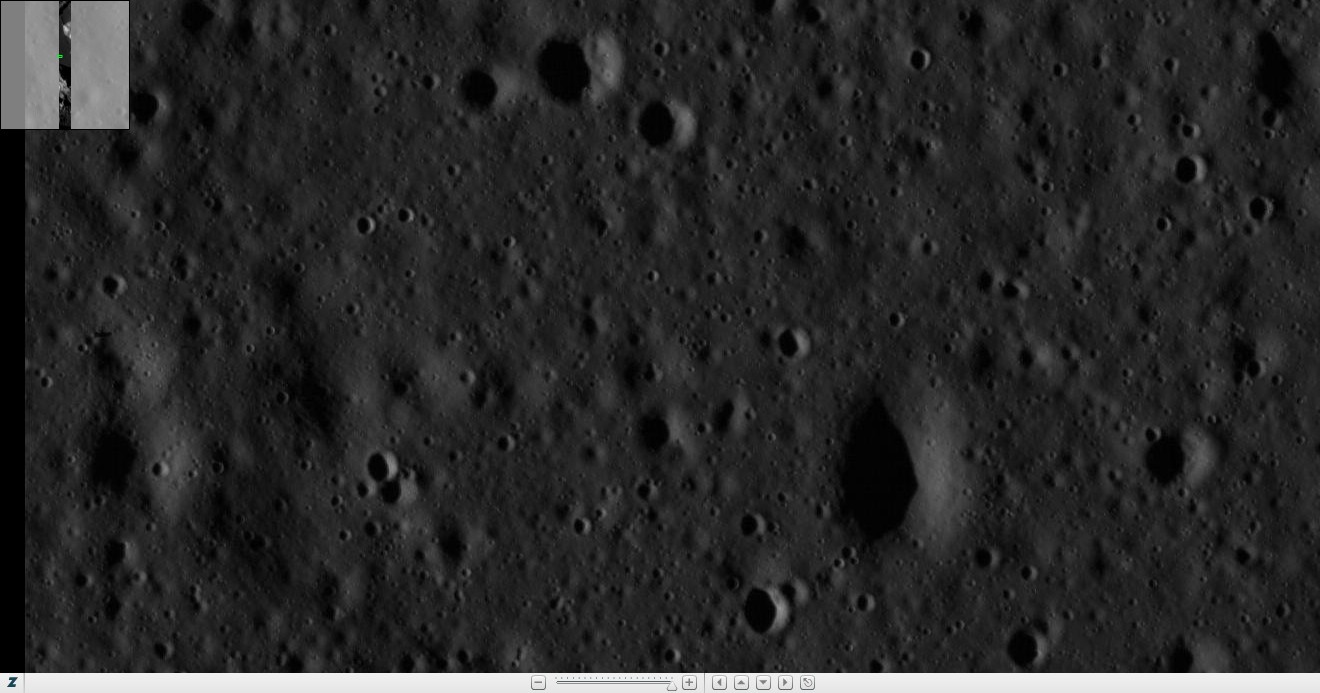
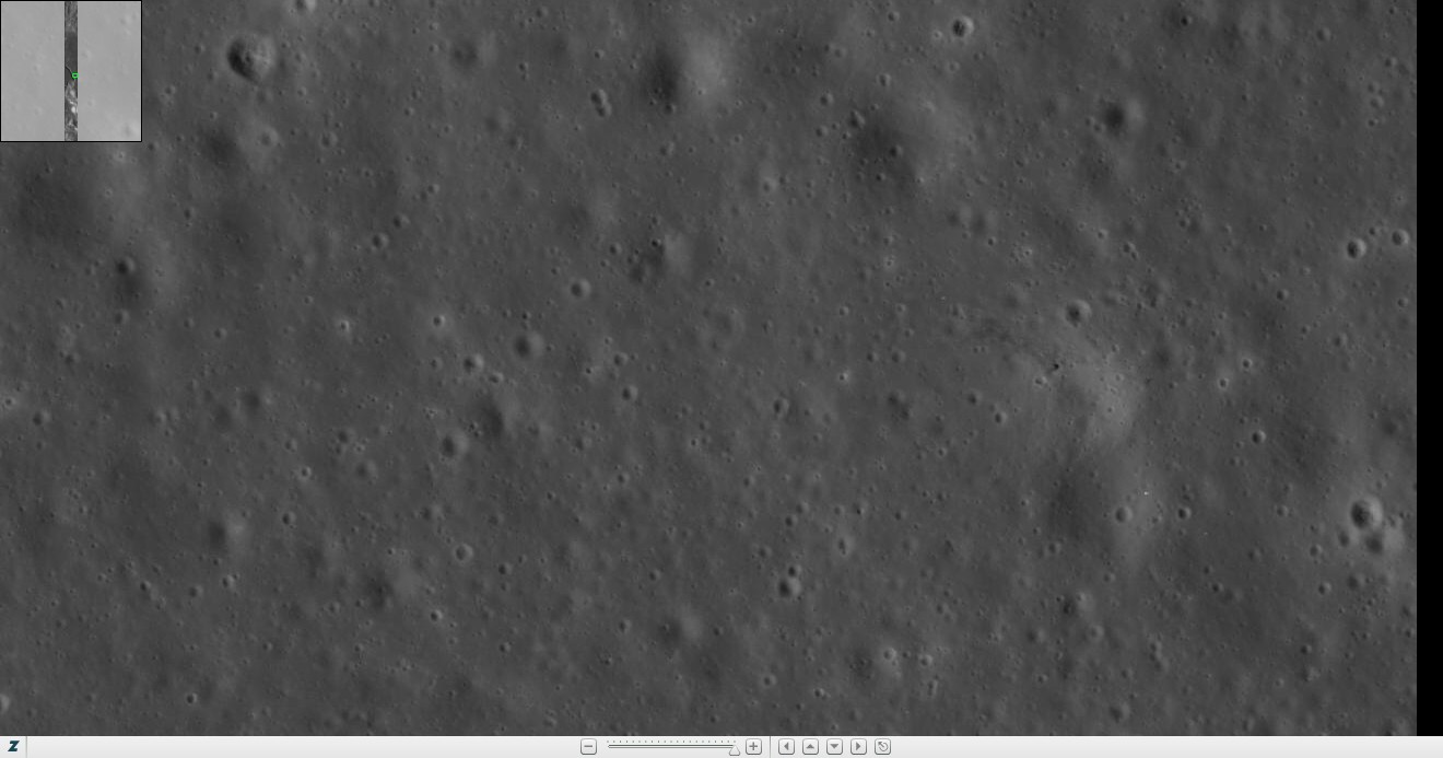
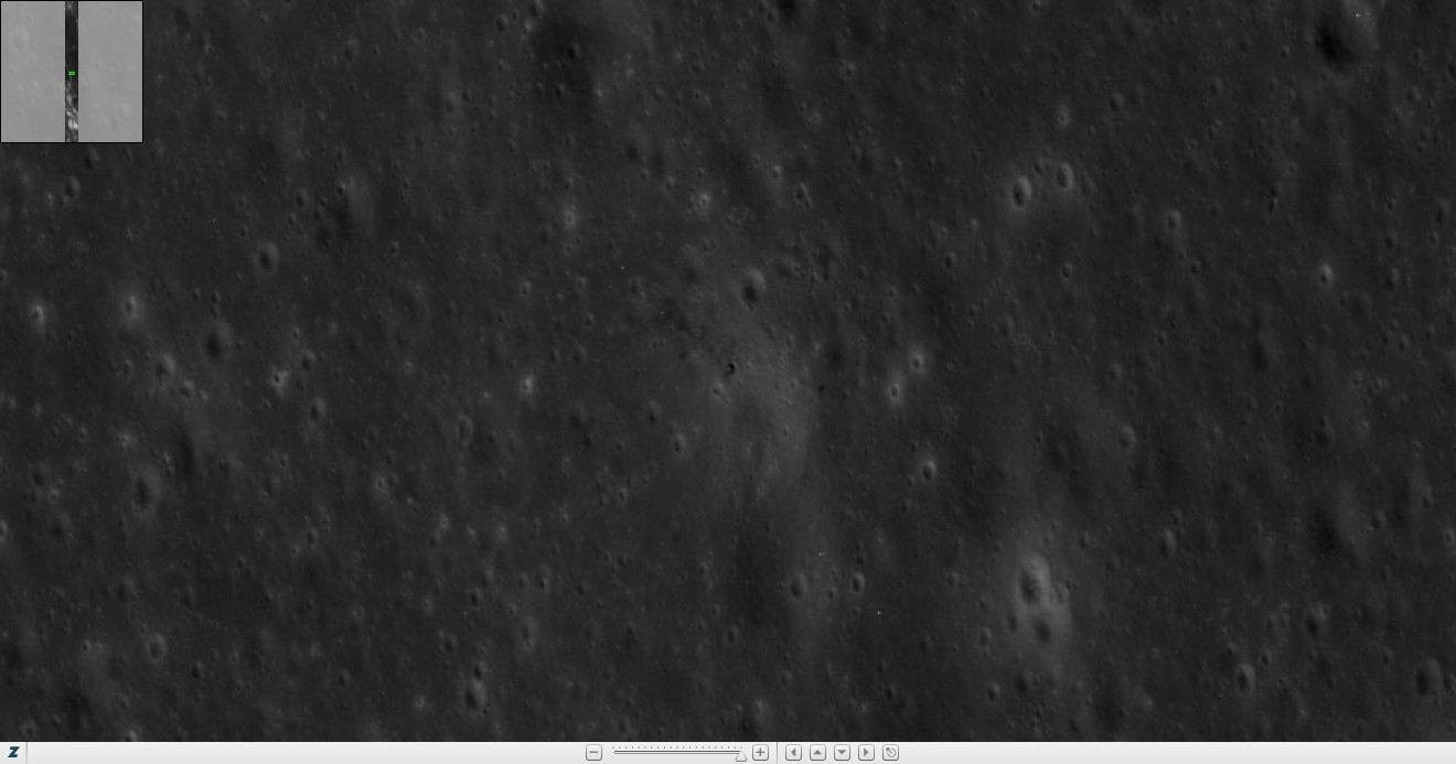
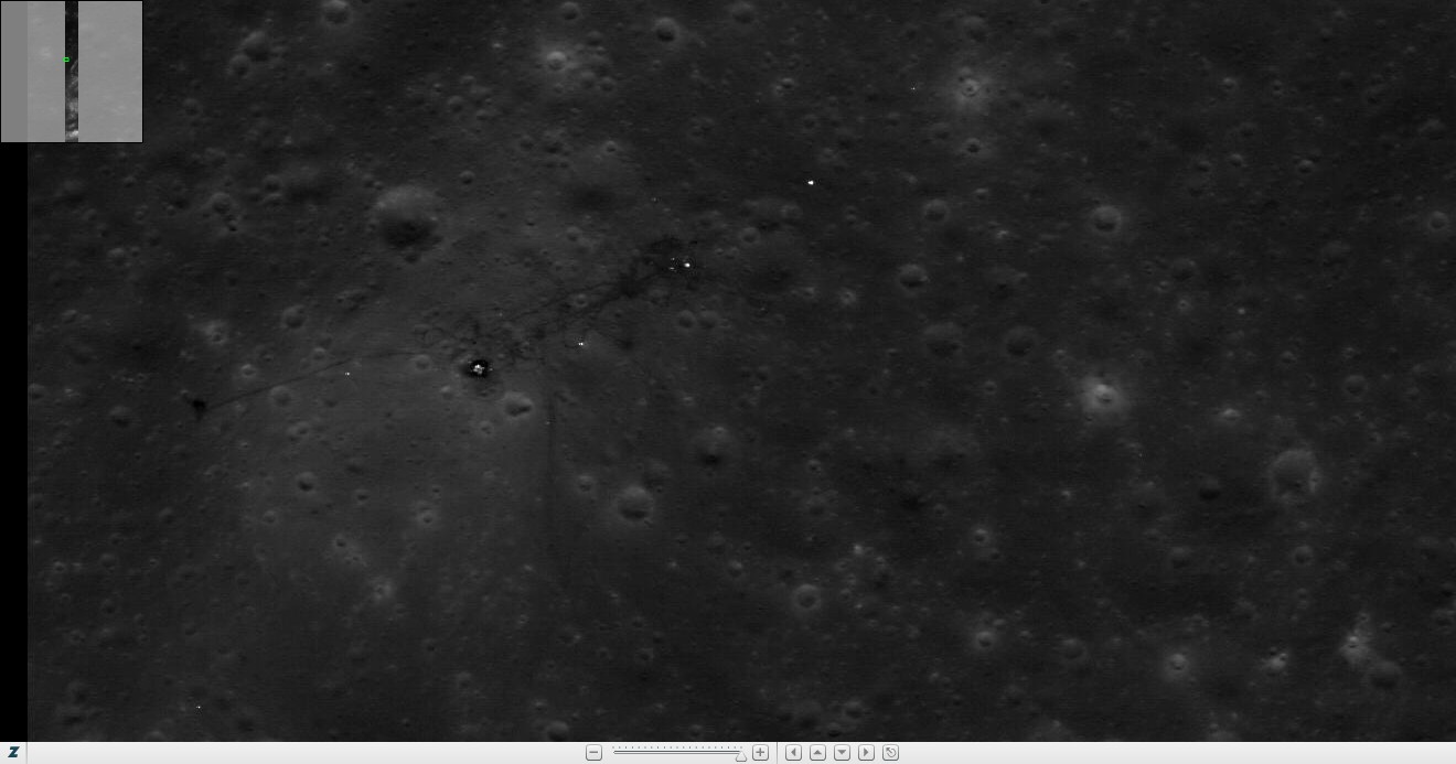
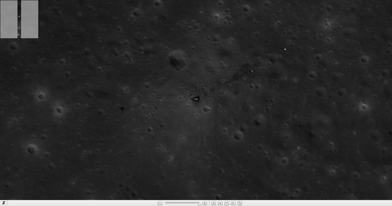
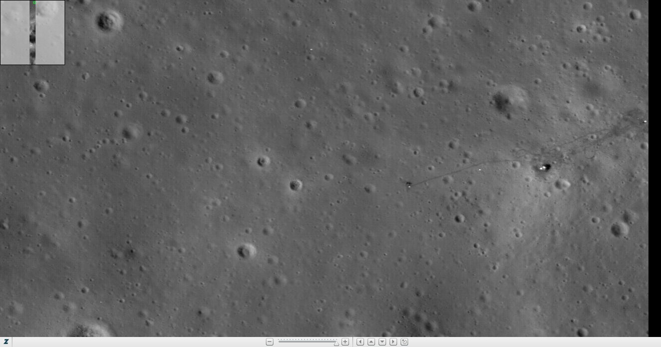
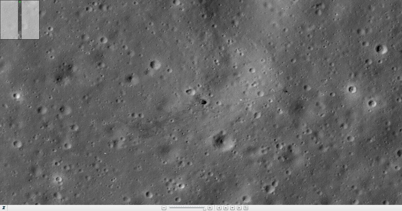
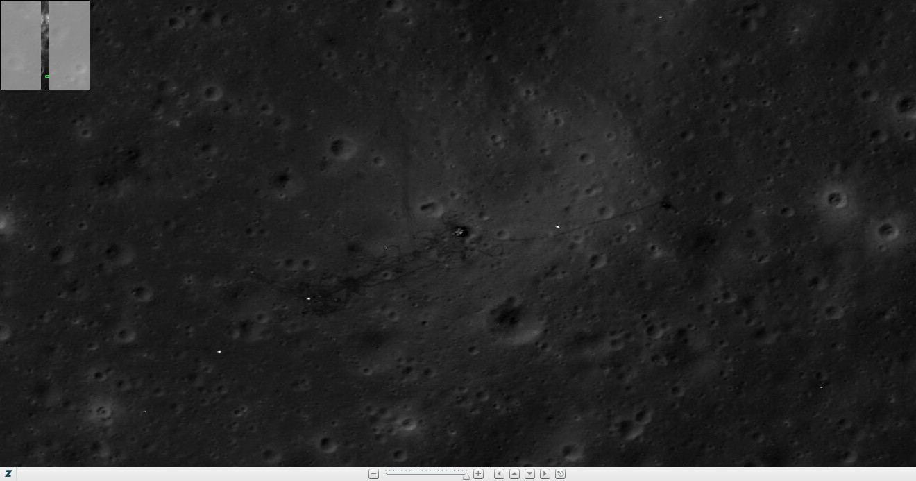
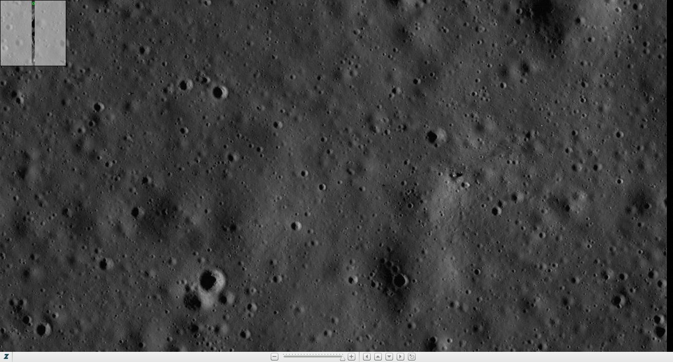
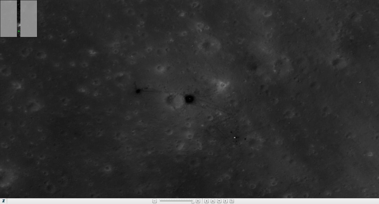
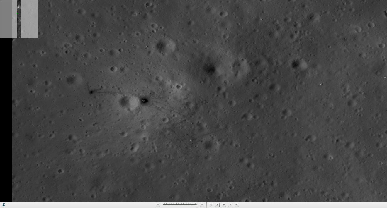
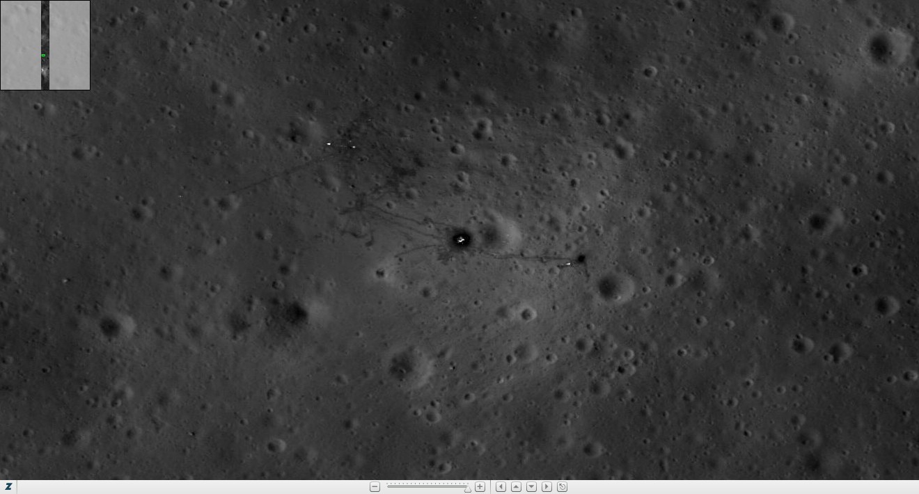
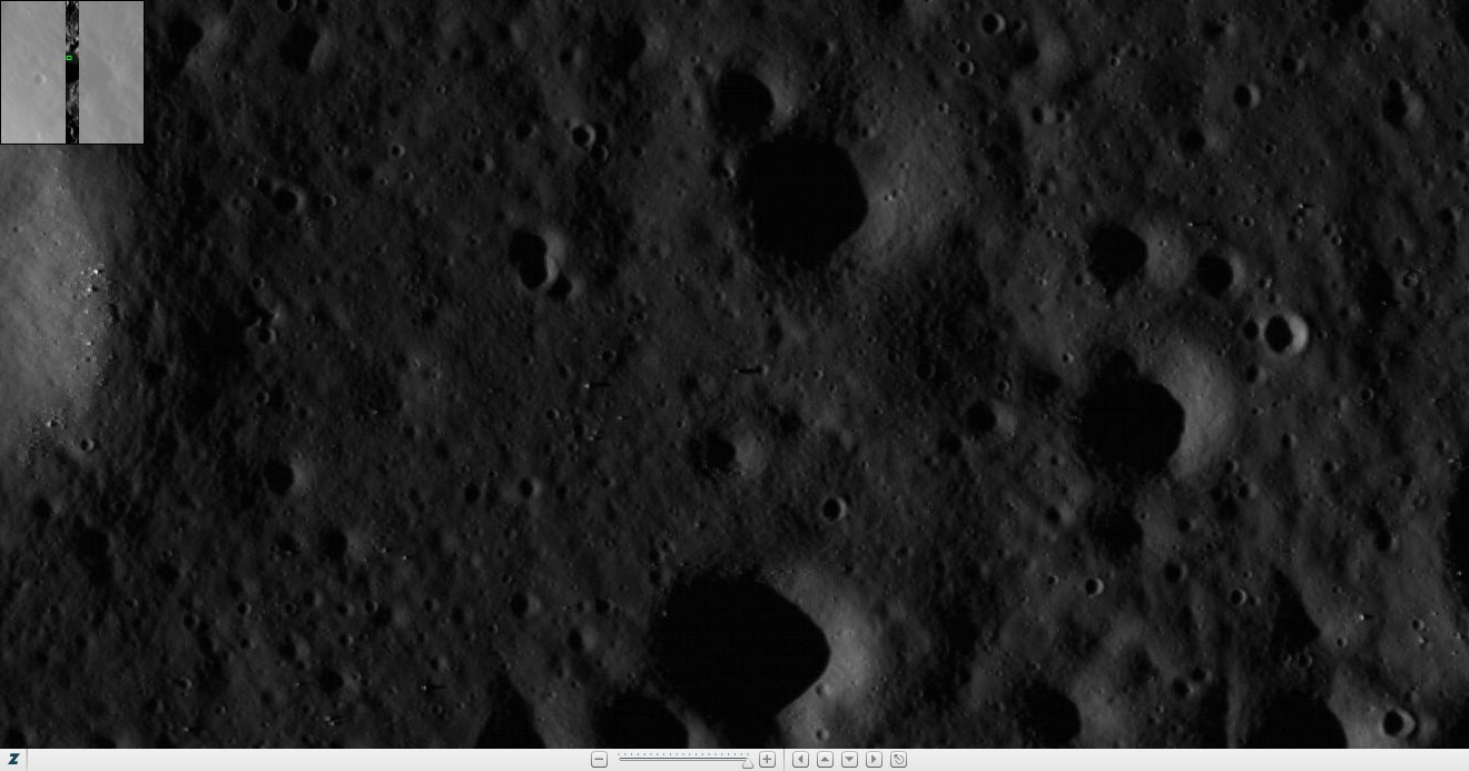
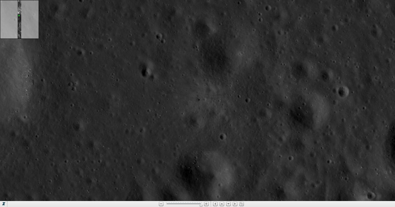
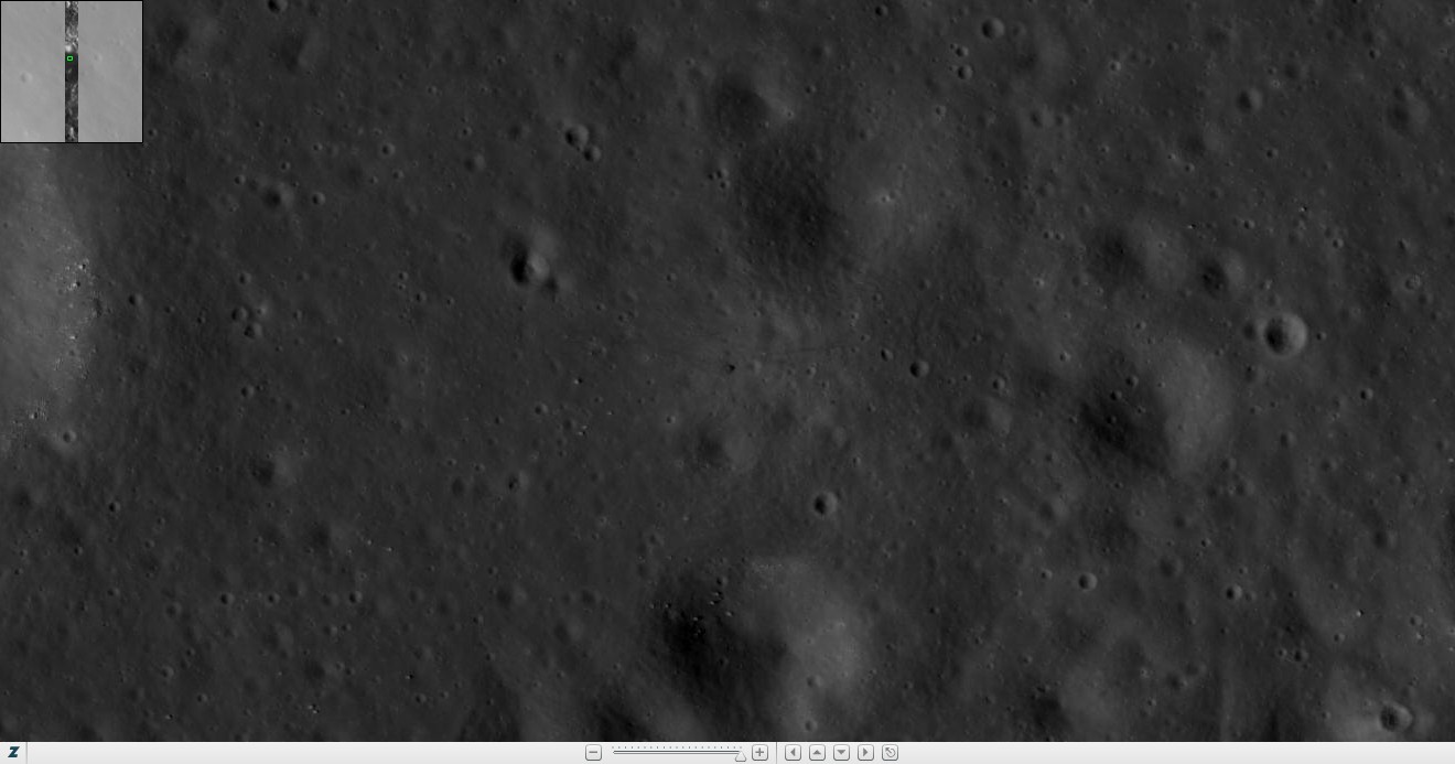
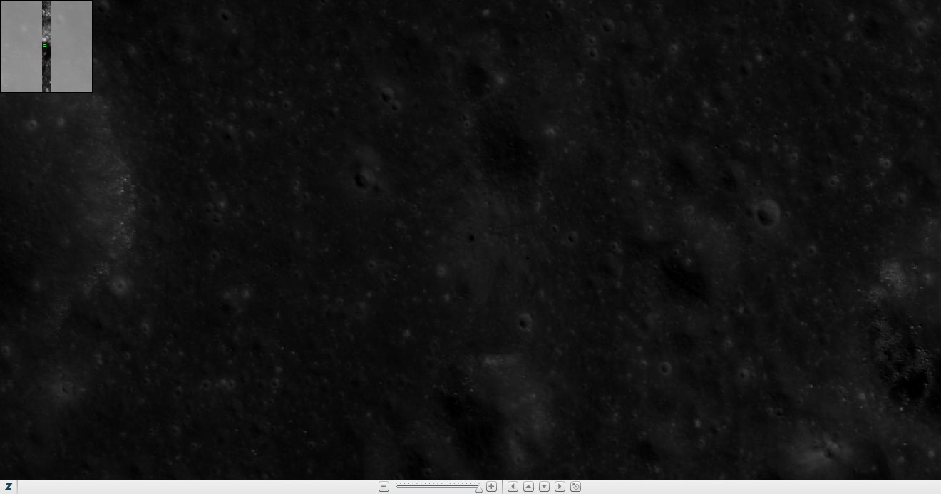
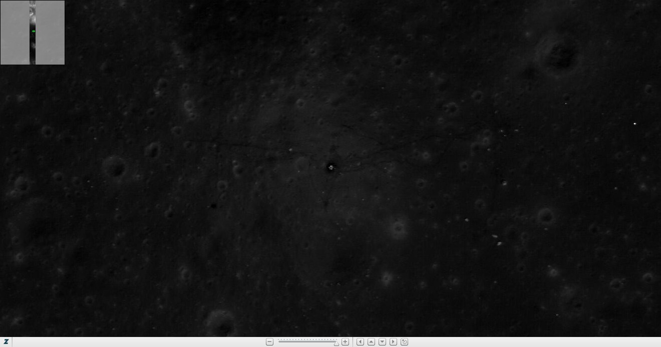
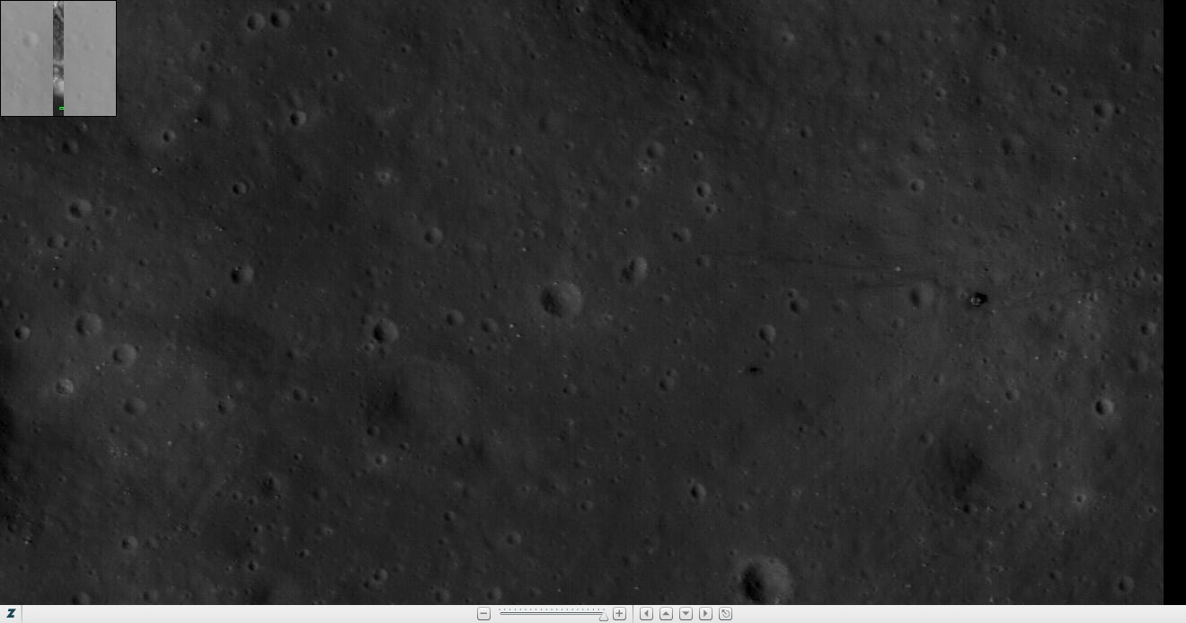
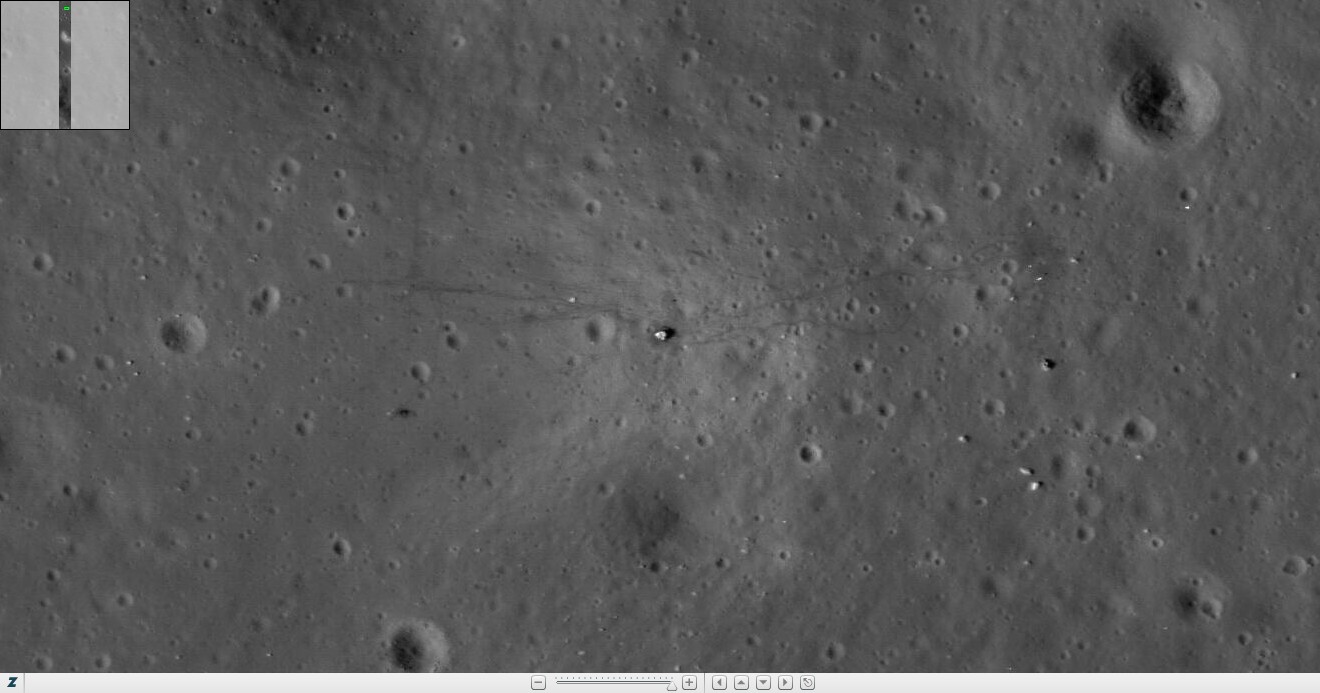
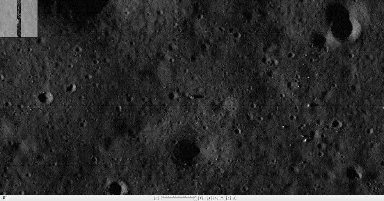
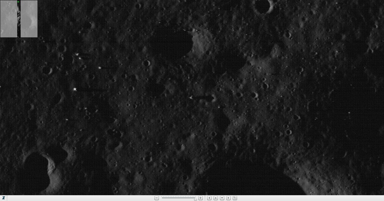
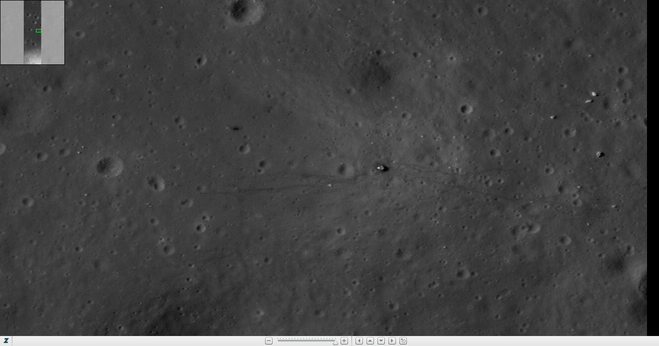
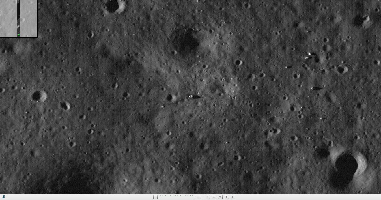
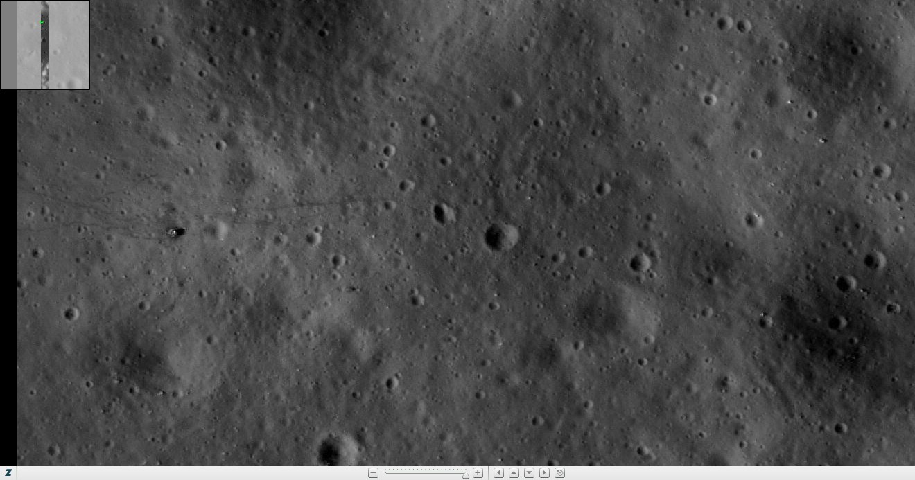
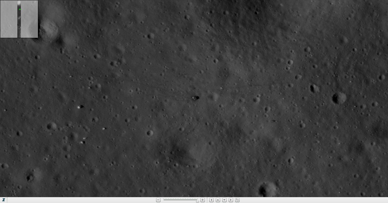
| Yellow
L or R letters indicate the left
or right NAC image which shows the LM descent stage. Orange
L or R letters indicate the left
or right NAC image which shows other hardware left behind by the Apollo
astronauts. The image directly below each NAC image pair shows where the LM
descent stage is located in the corresponding
L or R NAC image. |
|
|
|
|
Apollo
12 LROC NAC Image Information
Revision
Level: PDS Releases 1 through 6 |
| NAC Image Name |
Date |
Time |
LM |
LM |
Mission |
Slew |
X Scale |
Y Scale |
Incidence |
Solar |
Incidence |
Comments |
| |
|
|
Location |
Location |
Phase |
Angle |
(m/pixel) |
(m/pixel) |
Angle |
Altitude |
Direction |
|
| |
|
|
(Column) |
(Row) |
Name |
(degrees) |
|
|
(degrees) |
(degrees) |
|
|
| M104662862RE |
08/11/2009 |
20:46:35 |
4198 |
20304 |
COMMISSIONING |
-14.52 |
1.09 |
1.09 |
49.56 |
40.44 |
west |
Published first look |
| M107035386RE |
09/08/2009 |
07:48:39 |
393 |
19352 |
COMMISSIONING |
12.82 |
1.16 |
1.15 |
24.77 |
65.23 |
west |
|
| M109386083RE |
10/05/2009 |
12:46:55 |
4446 |
25414 |
NOMINAL |
-3.50 |
0.45 |
0.55 |
3.63 |
86.37 |
east |
|
| M114104917RE |
11/29/2009 |
03:34:10 |
1548 |
1774 |
NOMINAL |
-5.88 |
0.43 |
0.55 |
58.11 |
31.89 |
east |
|
| M116466489RE |
12/26/2009 |
11:33:42 |
1408 |
39005 |
NOMINAL |
6.00 |
0.43 |
0.55 |
85.68 |
4.32 |
east |
Underexposed |
| M117650516RE. |
01/09/2010 |
04:27:30 |
3419 |
2616 |
NOMINAL |
-7.18 |
0.44 |
0.55 |
80.60 |
9.40 |
west |
Sunset photograph |
| M120005333RE |
02/05/2010 |
10:34:26 |
2715 |
49435 |
NOMINAL |
19.15 |
0.48 |
0.55 |
52.19 |
37.81 |
west |
Stereo Pair #1 |
| M120012135RE |
02/05/2010 |
12:27:48 |
2827 |
2014 |
NOMINAL |
-19.57 |
0.49 |
0.55 |
53.05 |
36.95 |
west |
Stereo Pair #1 |
| M124728623LE |
04/01/2010 |
02:35:57 |
2880 |
2184 |
NOMINAL |
-6.44 |
0.45 |
0.55 |
4.73 |
85.27 |
east |
|
| M131806467LE |
06/22/2010 |
00:40:00 |
2830 |
48937 |
NOMINAL |
-6.53 |
0.43 |
0.55 |
82.05 |
7.95 |
east |
Sunrise photograph |
| M132983773RE |
07/05/2010 |
15:41:46 |
2682 |
24622 |
NOMINAL |
12.83 |
0.45 |
0.55 |
84.28 |
5.72 |
west |
Sunset photograph |
| M135338254RE |
08/01/2010 |
21:43:07 |
4346 |
49463 |
NOMINAL |
-15.27 |
0.46 |
0.55 |
57.33 |
32.67 |
west |
|
| M137699517LE |
08/29/2010 |
05:37:30 |
2789 |
2938 |
NOMINAL |
1.69 |
0.43 |
0.55 |
31.24 |
58.76 |
west |
|
| M140053756LE |
09/25/2010 |
11:34:49 |
4146 |
50238 |
SCIENCE |
-24.79 |
0.53 |
0.55 |
3.90 |
86.10 |
west |
Stereo Pair #2 |
| M140060558LE |
09/25/2010 |
13:28:10 |
4094 |
803 |
SCIENCE |
13.71 |
0.45 |
0.55 |
5.06 |
84.94 |
west |
Stereo Pair #2 |
| M141237780 |
10/09/2010 |
04:28:32 |
? |
? |
SCIENCE |
18.80 |
0.47 |
0.55 |
169.95 |
-79.95 |
east |
Earthlit Stereo Pair #3 |
| M141244565RE |
10/09/2010 |
06:21:37 |
? |
? |
SCIENCE |
-20.30 |
0.49 |
0.55 |
170.77 |
-80.77 |
east |
Earthlit Stereo Pair #3 |
| M142415059RE |
10/22/2010 |
19:29:51 |
1205 |
2675 |
SCIENCE |
-12.03 |
0.44 |
0.55 |
23.12 |
66.88 |
east |
|
| M144775952LE |
11/19/2010 |
03:18:04 |
3234 |
8767 |
SCIENCE |
0.00 |
0.42 |
0.55 |
50.33 |
39.67 |
east |
Zero slew angle |
| M148319683RE |
12/30/2010 |
03:40:15 |
624 |
4872 |
SCIENCE |
-18.48 |
0.46 |
0.91 |
88.30 |
1.70 |
west |
|
Apollo
12 LROC NAC Footprints at -3.01°, -23.42°
Revision Level: PDS Releases 1 through 6 |
| Yellow
L or R letters indicate the left
or right NAC image which shows the LM descent stage. Orange
L or R letters indicate the left
or right NAC image which shows other hardware left behind by the Apollo
astronauts. The image directly below each NAC image pair shows where the LM
descent stage is located in the corresponding
L or R NAC image. |
|
|
M141237780L/R


M141244565L/R


|
Apollo
14 LROC NAC Image Information
Revision
Level: PDS Releases 1 through 6 |
| NAC Image Name |
Date |
Time |
LM |
LM |
Mission |
Slew |
X Scale |
Y Scale |
Incidence |
Solar |
Incidence |
Comments |
| |
|
|
Location |
Location |
Phase |
Angle |
(m/pixel) |
(m/pixel) |
Angle |
Altitude |
Direction |
|
| |
|
|
(Column) |
(Row) |
Name |
(degrees) |
|
|
(degrees) |
(degrees) |
|
|
| M102265088LE |
07/15/2009 |
02:43:41 |
4705 |
18230 |
COMMISSIONING |
-11.26 |
1.07 |
1.08 |
76.23 |
13.77 |
west |
Published first look |
| M104627085LE |
08/11/2009 |
10:50:18 |
3008 |
28682 |
COMMISSIONING |
-5.60 |
1.06 |
1.10 |
50.38 |
39.62 |
west |
Stereo Pair #1 |
| M104634241LE |
08/11/2009 |
12:49:34 |
3108 |
29071 |
COMMISSIONING |
12.34 |
1.09 |
1.09 |
51.38 |
38.62 |
west |
Stereo Pair #1 |
| M106985205LE |
09/07/2009 |
17:52:18 |
2842 |
15306 |
COMMISSIONING |
-9.92 |
1.14 |
1.14 |
23.82 |
66.18 |
west |
|
| M109345337LE |
10/05/2009 |
01:27:49 |
4041 |
20021 |
NOMINAL |
-13.90 |
0.51 |
0.55 |
3.77 |
86.23 |
west |
|
| M111708164LE |
11/01/2009 |
09:48:16 |
2822 |
17379 |
NOMINAL |
2.00 |
0.48 |
0.55 |
29.87 |
60.13 |
east |
Oblique Stereo Pair #1 |
| M114064206LE |
11/28/2009 |
16:15:39 |
3406 |
48880 |
NOMINAL |
-17.90 |
0.50 |
0.55 |
57.86 |
32.14 |
east |
Stereo Pair #2 |
| M114071006LE |
11/28/2009 |
18:08:59 |
4588 |
2245 |
NOMINAL |
20.00 |
0.52 |
0.55 |
56.94 |
33.06 |
east |
Stereo Pair #2 |
| M114071006RE |
11/28/2009 |
18:08:59 |
? |
2245 |
NOMINAL |
20.00 |
0.51 |
0.55 |
57.02 |
32.98 |
east |
Rest of landing site area |
| M116425798LE |
12/26/2009 |
00:15:31 |
4080 |
13304 |
NOMINAL |
-6.79 |
0.46 |
0.55 |
85.43 |
4.57 |
east |
Underexposed |
| M117609776RE |
01/08/2010 |
17:08:29 |
2925 |
49685 |
NOMINAL |
2.80 |
0.41 |
0.55 |
80.85 |
9.15 |
west |
|
| M119971387RE |
02/05/2010 |
01:08:41 |
2961 |
59136 |
NOMINAL |
-10.73 |
0.42 |
0.55 |
53.37 |
36.63 |
west |
|
| M124687860RE |
03/31/2010 |
15:16:34 |
3043 |
49468 |
NOMINAL |
0.77 |
0.42 |
0.55 |
5.98 |
84.02 |
east |
|
| M127049821RE |
04/27/2010 |
23:22:36 |
2816 |
50849 |
NOMINAL |
-15.32 |
0.43 |
0.55 |
29.12 |
60.88 |
east |
Oblique Stereo Pair #1 |
| M129404545RE |
05/25/2010 |
05:27:58 |
2983 |
25223 |
NOMINAL |
13.08 |
0.43 |
0.55 |
55.93 |
34.07 |
east |
|
| M131765772RE |
06/21/2010 |
13:21:44 |
3109 |
2167 |
NOMINAL |
0.82 |
0.40 |
0.55 |
81.84 |
8.16 |
east |
|
| M132943081RE |
07/05/2010 |
04:23:33 |
3345 |
20983 |
NOMINAL |
2.00 |
0.45 |
0.55 |
84.47 |
5.53 |
west |
|
| M140019848RE |
09/25/2010 |
02:09:40 |
4849 |
30537 |
SCIENCE |
0.00 |
0.45 |
0.55 |
5.29 |
84.71 |
west |
|
| M148278998LE |
12/29/2010 |
16:22:10 |
1397 |
5527 |
SCIENCE |
-11.70 |
0.40 |
0.84 |
88.51 |
1.49 |
west |
|
| M150633128LE |
01/25/2011 |
22:17:41 |
4020 |
14703 |
SCIENCE |
15.17 |
0.43 |
0.55 |
59.90 |
30.10 |
west |
Stereo Pair #3 |
| M150639913LE |
01/26/2011 |
00:10:45 |
3306 |
14809 |
SCIENCE |
-26.46 |
0.49 |
0.55 |
60.83 |
29.17 |
west |
Stereo Pair #3 |
| M152994220RE |
02/22/2011 |
06:09:13 |
4680 |
2714 |
SCIENCE |
0.01 |
0.40 |
0.55 |
32.51 |
57.49 |
west |
|
Apollo 14 LROC NAC
Footprints at -3.65°, -17.47°
Revision Level: PDS Releases 1 through 6 |
| Yellow L or R letters indicate the left or
right NAC image which shows the LM descent stage. Orange
L or R letters indicate the left
or right NAC image which shows other hardware left behind by the Apollo
astronauts. The image directly below each NAC image pair shows where the LM
descent stage is located in the corresponding
L or R NAC image. |
|
|
|
|
Apollo
15 LROC NAC Image Information
Revision
Level: PDS Releases 1 through 6 |
| NAC Image Name |
Date |
Time |
LM |
LM |
Mission |
Slew |
X Scale |
Y Scale |
Incidence |
Solar |
Incidence |
Comments |
| |
|
|
Location |
Location |
Phase |
Angle |
(m/pixel) |
(m/pixel) |
Angle |
Altitude |
Direction |
|
| |
|
|
(Column) |
(Row) |
Name |
(degrees) |
|
|
(degrees) |
(degrees) |
|
|
| M102128467RE |
07/13/2009 |
12:46:40 |
4439 |
23515 |
COMMISSIONING |
-12.68 |
1.51 |
1.46 |
79.26 |
10.74 |
west |
Published first look, Stereo Pair #1 |
| M102135625LE |
07/13/2009 |
14:45:58 |
3534 |
23785 |
COMMISSIONING |
0.00 |
1.45 |
1.46 |
80.01 |
9.99 |
west |
Stereo Pair #1 |
| M102142784RE |
07/13/2009 |
16:45:17 |
4971 |
22833 |
COMMISSIONING |
10.85 |
1.51 |
1.46 |
81.07 |
8.93 |
west |
Stereo Pair #1 |
| M104490494LE |
08/09/2009 |
20:53:47 |
4708 |
27896 |
COMMISSIONING |
-9.04 |
1.51 |
1.45 |
56.78 |
33.22 |
west |
|
| M106855508LE |
09/06/2009 |
05:50:41 |
2937 |
26844 |
COMMISSIONING |
0.00 |
1.55 |
0.99 |
37.37 |
52.63 |
west |
|
| M109215691RE |
10/03/2009 |
13:27:03 |
4630 |
21909 |
NOMINAL |
5.00 |
0.49 |
0.54 |
27.56 |
62.44 |
east |
|
| M111571816LE |
10/30/2009 |
19:55:49 |
2546 |
22381 |
NOMINAL |
-13.50 |
0.50 |
0.55 |
38.55 |
51.45 |
east |
Stereo Pair #2 |
| M111578606LE |
10/30/2009 |
21:48:58 |
4736 |
22385 |
NOMINAL |
20.00 |
0.55 |
0.55 |
37.91 |
52.09 |
east |
Stereo Pair #2 |
| M113934743LE |
11/27/2009 |
04:17:56 |
4829 |
1871 |
NOMINAL |
4.09 |
0.46 |
0.55 |
59.46 |
30.54 |
east |
Fair possibility of showing rover |
| M116296299RE |
12/24/2009 |
12:17:12 |
? |
? |
NOMINAL |
17.29 |
0.50 |
0.55 |
83.59 |
6.41 |
east |
Landing site in shadow |
| M117467833RE |
01/07/2010 |
01:42:46 |
2908 |
25929 |
NOMINAL |
-5.67 |
0.41 |
0.55 |
82.82 |
7.18 |
west |
Rover antenna and rover shadow |
| M119822622LE |
02/03/2010 |
07:49:16 |
3138 |
49667 |
NOMINAL |
16.63 |
0.45 |
0.55 |
57.18 |
32.82 |
west |
VG rover possibility, Stereo Pair #3 |
| M119829425LE |
02/03/2010 |
09:42:39 |
3012 |
2292 |
NOMINAL |
-18.97 |
0.45 |
0.55 |
58.21 |
31.79 |
west |
VG rover possibility, Stereo Pair #3 |
| M122184104RE |
03/02/2010 |
15:47:17 |
3920 |
44754 |
NOMINAL |
9.68 |
0.42 |
0.55 |
35.07 |
54.93 |
west |
Good possibility of showing rover |
| M126901141RE |
04/26/2010 |
06:04:35 |
2763 |
1356 |
NOMINAL |
17.10 |
0.44 |
0.55 |
37.12 |
52.88 |
east |
Good possibility of showing rover |
| M131623862LE |
06/19/2010 |
21:56:34 |
1567 |
2198 |
NOMINAL |
0.00 |
0.40 |
0.55 |
81.58 |
8.42 |
east |
Excellent possibility of showing rover |
| M146959973LE |
12/14/2010 |
09:58:25 |
2104 |
2545 |
SCIENCE |
0.00 |
0.43 |
0.95 |
77.24 |
12.76 |
east |
Low sunrise photograph |
| M148137179RE |
12/28/2010 |
00:58:32 |
? |
? |
SCIENCE |
-5.50 |
0.38 |
0.83 |
89.93 |
0.07 |
west |
Landing site in shadow |
Apollo 15 ROC NAC
Footprints at 26.13°, 3.64°
Revision Level: PDS Releases 1 through 6 |
| Yellow L or R letters indicate the left or
right NAC image which shows the LM descent stage. Orange
L or R letters indicate the left
or right NAC image which shows other hardware left behind by the Apollo
astronauts. The image directly below each NAC image pair shows where the LM
descent stage is located in the corresponding
L or R NAC image. |
|
|
M116296299L/R


M148137179L/R


|
Apollo
16 LROC NAC Image Information
Revision
Level: PDS Releases 1 through 6 |
| NAC Image Name |
Date |
Time |
LM |
LM |
Mission |
Slew |
X Scale |
Y Scale |
Incidence |
Solar |
Incidence |
Comments |
| |
|
|
Location |
Location |
Phase |
Angle |
(m/pixel) |
(m/pixel) |
Angle |
Altitude |
Direction |
|
| |
|
|
(Column) |
(Row) |
Name |
(degrees) |
|
|
(degrees) |
(degrees) |
|
|
| M102064759RE |
07/12/2009 |
19:04:52 |
3005 |
21128 |
COMMISSIONING |
20.00 |
1.14 |
1.05 |
81.08 |
8.92 |
west |
Published first look |
| M106777343RE |
09/05/2009 |
08:07:56 |
2284 |
19760 |
COMMISSIONING |
0.00 |
1.07 |
1.13 |
23.38 |
66.62 |
west |
|
| M109134835LE |
10/02/2009 |
14:59:28 |
3035 |
17241 |
NOMINAL |
0.00 |
0.49 |
0.54 |
7.64 |
82.36 |
east |
|
| M113853974RE |
11/26/2009 |
05:51:47 |
1339 |
47274 |
NOMINAL |
1.18 |
0.47 |
0.55 |
54.72 |
35.28 |
east |
|
| M116215545RE |
12/23/2009 |
13:51:18 |
973 |
13054 |
NOMINAL |
11.98 |
0.48 |
0.55 |
82.08 |
7.92 |
east |
Sunrise photograph |
| M117392541LE |
01/06/2010 |
04:47:54 |
2947 |
25867 |
NOMINAL |
-14.80 |
0.45 |
0.55 |
83.30 |
6.70 |
west |
Sunset photograph |
| M122108795LE |
03/01/2010 |
18:52:09 |
2835 |
44611 |
NOMINAL |
0.60 |
0.43 |
0.55 |
29.17 |
60.83 |
west |
|
| M126825870LE |
04/25/2010 |
09:10:04 |
1349 |
4402 |
NOMINAL |
14.50 |
0.44 |
0.55 |
28.92 |
61.08 |
east |
|
| M129187331LE |
05/22/2010 |
17:07:46 |
3064 |
24792 |
NOMINAL |
0.00 |
0.42 |
0.55 |
54.19 |
35.81 |
east |
|
| M131548593RE |
06/19/2010 |
01:02:06 |
2952 |
2179 |
NOMINAL |
-15.48 |
0.44 |
0.55 |
79.72 |
10.28 |
east |
Sunrise photograph |
| M132732855RE |
07/02/2010 |
17:59:48 |
522 |
25741 |
NOMINAL |
18.04 |
0.51 |
0.55 |
87.78 |
2.22 |
west |
Sunset photograph |
| M142164190RE |
10/19/2010 |
21:48:42 |
3119 |
44066 |
SCIENCE |
-6.18 |
0.45 |
0.55 |
20.60 |
69.40 |
east |
|
| M144524996LE |
11/16/2010 |
05:35:29 |
490 |
18371 |
SCIENCE |
2.00 |
0.45 |
0.55 |
47.18 |
42.82 |
east |
|
| M152770233RE |
02/19/2011 |
15:56:06 |
1571 |
32207 |
SCIENCE |
23.48 |
0.47 |
0.55 |
35.19 |
54.81 |
west |
Stereo Pair #1 |
| M152777016RE |
02/19/2011 |
17:49:09 |
1371 |
32779 |
SCIENCE |
-18.86 |
0.45 |
0.55 |
36.10 |
53.90 |
west |
Stereo Pair #1 |
Apollo 16 LROC NAC
Footprints at -8.97°, 15.5°
Revision Level: PDS Releases 1 through 6 |
| Yellow L or R letters indicate the left or
right NAC image which shows the LM descent stage. Orange
L or R letters indicate the left
or right NAC image which shows other hardware left behind by the Apollo
astronauts. The image directly below each NAC image pair shows where the LM
descent stage is located in the corresponding
L or R NAC image. |
|
|
|
|
Apollo
17 LROC NAC Image Information
Revision
Level: PDS Releases 1 through 6 |
| NAC Image Name |
Date |
Time |
LM |
LM |
Mission |
Slew |
X Scale |
Y Scale |
Incidence |
Solar |
Incidence |
Comments |
| |
|
|
Location |
Location |
Phase |
Angle |
(m/pixel) |
(m/pixel) |
Angle |
Altitude |
Direction |
|
| |
|
|
(Column) |
(Row) |
Name |
(degrees) |
|
|
(degrees) |
(degrees) |
|
|
| M101949648RE |
07/11/2009 |
11:06:21 |
1830 |
20534 |
COMMISSIONING |
-15.37 |
1.47 |
1.39 |
80.47 |
9.53 |
west |
Published first look, Stereo Pair #1 |
| M101956806LE |
07/11/2009 |
13:05:39 |
1077 |
21060 |
COMMISSIONING |
0.00 |
1.37 |
1.39 |
81.43 |
8.57 |
west |
Stereo Pair #1 |
| M101963963RE |
07/11/2009 |
15:04:56 |
1471 |
21007 |
COMMISSIONING |
9.42 |
1.41 |
1.39 |
82.34 |
7.66 |
west |
Stereo Pair #1 |
| M104311715RE |
08/07/2009 |
19:14:08 |
2136 |
20961 |
COMMISSIONING |
12.17 |
1.45 |
1.40 |
56.74 |
33.26 |
west |
Stereo Pair #2 |
| M104318871RE |
08/07/2009 |
21:13:24 |
2188 |
21358 |
COMMISSIONING |
0.00 |
1.39 |
1.40 |
57.64 |
32.36 |
west |
Stereo Pair #2 |
| M106690695RE |
09/04/2009 |
08:03:48 |
1780 |
25939 |
COMMISSIONING |
18.56 |
1.65 |
1.47 |
36.60 |
53.40 |
west |
|
| M109032389LE |
10/01/2009 |
10:32:01 |
3738 |
25243 |
NOMINAL |
19.51 |
0.54 |
0.54 |
21.69 |
68.31 |
west |
|
| M113751661LE |
11/25/2009 |
01:26:34 |
4829 |
48946 |
NOMINAL |
-20.00 |
0.50 |
0.55 |
56.73 |
33.27 |
east |
Stereo Pair #3 |
| M113751661RE |
11/25/2009 |
01:26:34 |
? |
48946 |
NOMINAL |
-20.00 |
0.51 |
0.55 |
56.81 |
33.19 |
east |
Rest of Landing Site, Stereo Pair #3 |
| M113758461RE |
11/25/2009 |
03:19:54 |
3500 |
3246 |
NOMINAL |
15.62 |
0.48 |
0.55 |
55.72 |
34.28 |
east |
Stereo Pair #3 |
| M116113215RE |
12/22/2009 |
09:25:48 |
1623 |
39594 |
NOMINAL |
9.20 |
0.46 |
0.55 |
81.99 |
8.01 |
east |
Sunrise photograph |
| M117291316LE |
01/05/2010 |
00:40:50 |
1782 |
2414 |
NOMINAL |
-16.37 |
0.46 |
0.55 |
84.70 |
5.30 |
west |
Sunset photograph |
| M129086118LE |
05/21/2010 |
13:00:53 |
4506 |
8803 |
NOMINAL |
0.00 |
0.43 |
0.55 |
54.69 |
35.31 |
east |
Excellent morning image |
| M131447374LE |
06/17/2010 |
20:55:07 |
2903 |
48974 |
NOMINAL |
-9.92 |
0.43 |
0.55 |
79.14 |
10.86 |
east |
Sunrise photograph |
| M134985003LE |
07/28/2010 |
19:35:36 |
? |
12626 |
NOMINAL |
-20.00 |
0.50 |
0.55 |
63.73 |
26.27 |
west |
Rest of Landing Site |
| M134985003RE |
07/28/2010 |
19:35:36 |
247 |
12626 |
NOMINAL |
-20.00 |
0.49 |
0.55 |
63.81 |
26.19 |
west |
Stereo Pair #4 |
| M134991788LE |
07/28/2010 |
21:28:41 |
3926 |
12801 |
NOMINAL |
15.14 |
0.47 |
0.55 |
64.58 |
25.42 |
west |
Stereo Pair #4 |
Apollo 17 LROC NAC
Footprints at 20.19°, 30.77°
Revision Level: PDS Releases 1 through 6 |
| Yellow L or R letters indicate the left or
right NAC image which shows the LM descent stage. Orange
L or R letters indicate the left
or right NAC image which shows other hardware left behind by the Apollo
astronauts. The image directly below each NAC image pair shows where the LM
descent stage is located in the corresponding
L or R NAC image. |
|
|
|
|
| Copyright ©2005-MEM-TEK. All rights reserved. Site contents, services and terms of use
are subject to change without notice. |
|
|